You are here: Home > Network List > TA - USArray Transportable Network (new EarthScope stations) Stations List
> Station N06A Buffalo Meadows, Empire, NV, USA > Earthquake Result Viewer
N06A Buffalo Meadows, Empire, NV, USA - Earthquake Result Viewer
| Earthquake location: |
Solomon Islands |
| Earthquake latitude/longitude: |
-10.9/162.1 |
| Earthquake time(UTC): |
2007/11/27 (331) 11:49:58 GMT |
| Earthquake Depth: |
16 km |
| Earthquake Magnitude: |
5.9 MB, 6.7 MS, 6.6 MW, 6.4 MW |
| Earthquake Catalog/Contributor: |
WHDF/NEIC |
|
| Network: |
TA USArray Transportable Network (new EarthScope stations) |
| Station: |
N06A Buffalo Meadows, Empire, NV, USA |
| Lat/Lon: |
40.75 N/119.83 W |
| Elevation: |
1341 m |
|
| Distance: |
88.2 deg |
| Az: |
48.037 deg |
| Baz: |
253.972 deg |
| Ray Param: |
0.042786803 |
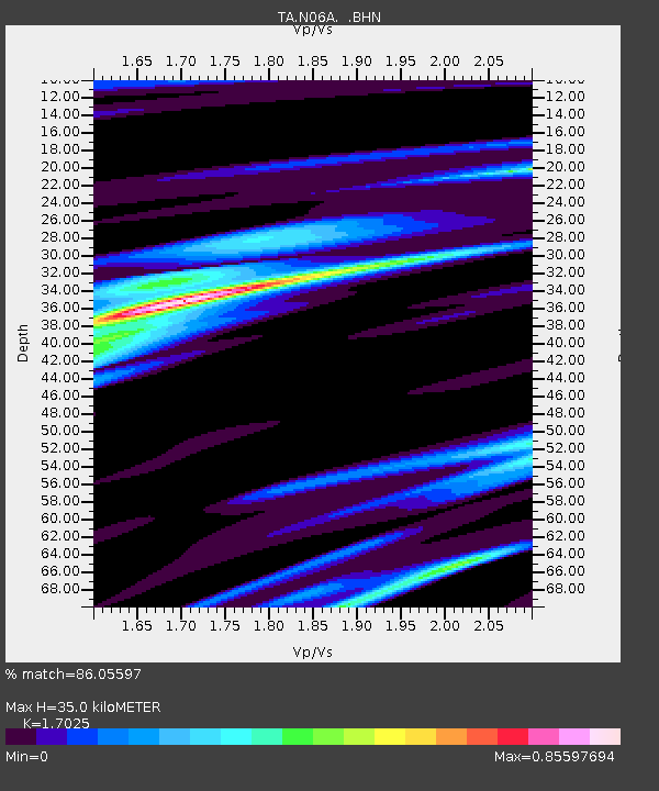
| Estimated Moho Depth: |
35.0 km |
| Estimated Crust Vp/Vs: |
1.70 |
| Assumed Crust Vp: |
6.276 km/s |
| Estimated Crust Vs: |
3.686 km/s |
| Estimated Crust Poisson's Ratio: |
0.24 |
|
| Radial Match: |
86.05597 % |
| Radial Bump: |
287 |
| Transverse Match: |
73.75184 % |
| Transverse Bump: |
378 |
| SOD ConfigId: |
2564 |
| Insert Time: |
2010-03-07 04:23:24.799 +0000 |
| GWidth: |
2.5 |
| Max Bumps: |
400 |
| Tol: |
0.001 |
|

Signal To Noise
| Channel | StoN | STA | LTA |
| TA:N06A: :BHN:20071127T12:02:16.424001Z | 1.2141212 | 1.7555539E-7 | 1.4459461E-7 |
| TA:N06A: :BHE:20071127T12:02:16.424001Z | 2.4034672 | 3.8452103E-7 | 1.5998597E-7 |
| TA:N06A: :BHZ:20071127T12:02:16.424001Z | 14.600056 | 1.448119E-6 | 9.918585E-8 |
| Arrivals |
| Ps | 4.0 SECOND |
| PpPs | 15 SECOND |
| PsPs/PpSs | 19 SECOND |


