You are here: Home > Network List > TA - USArray Transportable Network (new EarthScope stations) Stations List
> Station N06A Buffalo Meadows, Empire, NV, USA > Earthquake Result Viewer
N06A Buffalo Meadows, Empire, NV, USA - Earthquake Result Viewer
| Earthquake location: |
Ryukyu Islands, Japan |
| Earthquake latitude/longitude: |
28.6/129.9 |
| Earthquake time(UTC): |
2006/11/17 (321) 18:03:12 GMT |
| Earthquake Depth: |
22 km |
| Earthquake Magnitude: |
5.8 MB, 5.8 MS, 6.2 MW, 6.1 MW |
| Earthquake Catalog/Contributor: |
WHDF/NEIC |
|
| Network: |
TA USArray Transportable Network (new EarthScope stations) |
| Station: |
N06A Buffalo Meadows, Empire, NV, USA |
| Lat/Lon: |
40.75 N/119.83 W |
| Elevation: |
1341 m |
|
| Distance: |
85.5 deg |
| Az: |
45.633 deg |
| Baz: |
304.161 deg |
| Ray Param: |
0.044683035 |
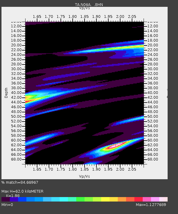
| Estimated Moho Depth: |
62.0 km |
| Estimated Crust Vp/Vs: |
1.98 |
| Assumed Crust Vp: |
6.276 km/s |
| Estimated Crust Vs: |
3.17 km/s |
| Estimated Crust Poisson's Ratio: |
0.33 |
|
| Radial Match: |
84.66967 % |
| Radial Bump: |
318 |
| Transverse Match: |
60.49068 % |
| Transverse Bump: |
400 |
| SOD ConfigId: |
2564 |
| Insert Time: |
2010-03-07 04:23:27.894 +0000 |
| GWidth: |
2.5 |
| Max Bumps: |
400 |
| Tol: |
0.001 |
|

Signal To Noise
| Channel | StoN | STA | LTA |
| TA:N06A: :BHN:20061117T18:15:17.025015Z | 1.7139246 | 6.6275857E-7 | 3.8669063E-7 |
| TA:N06A: :BHE:20061117T18:15:17.025015Z | 1.1121814 | 5.688231E-7 | 5.114481E-7 |
| TA:N06A: :BHZ:20061117T18:15:17.025015Z | 0.68695354 | 2.9617325E-7 | 4.3114017E-7 |
| Arrivals |
| Ps | 9.9 SECOND |
| PpPs | 29 SECOND |
| PsPs/PpSs | 39 SECOND |


