You are here: Home > Network List > TA - USArray Transportable Network (new EarthScope stations) Stations List
> Station N06A Buffalo Meadows, Empire, NV, USA > Earthquake Result Viewer
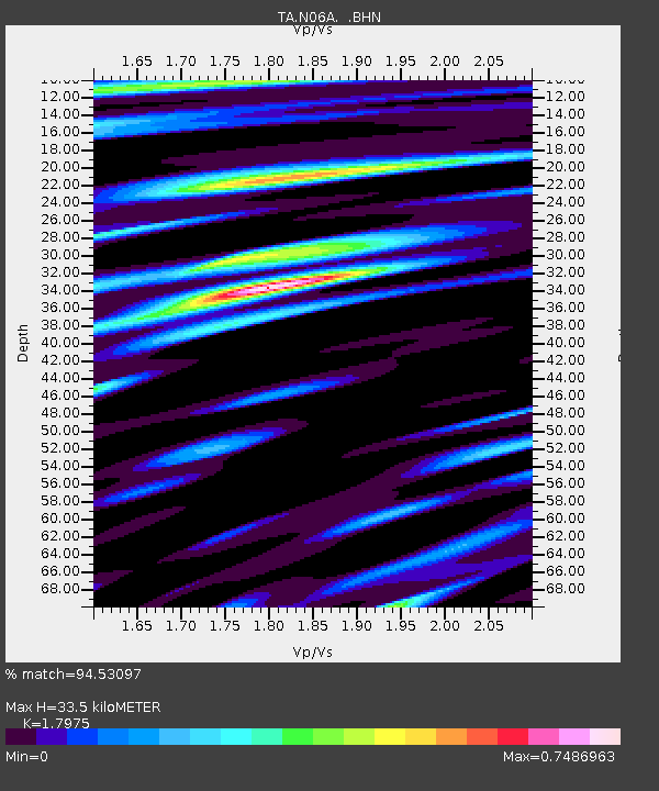
N06A Buffalo Meadows, Empire, NV, USA - Earthquake Result Viewer
| Earthquake location: |
Near Coast Of Peru |
| Earthquake latitude/longitude: |
-13.5/-76.7 |
| Earthquake time(UTC): |
2006/10/20 (293) 10:48:56 GMT |
| Earthquake Depth: |
23 km |
| Earthquake Magnitude: |
5.9 MB, 6.6 MS, 6.7 MW, 6.6 MW |
| Earthquake Catalog/Contributor: |
WHDF/NEIC |
|
| Network: |
TA USArray Transportable Network (new EarthScope stations) |
| Station: |
N06A Buffalo Meadows, Empire, NV, USA |
| Lat/Lon: |
40.75 N/119.83 W |
| Elevation: |
1341 m |
|
| Distance: |
67.1 deg |
| Az: |
325.663 deg |
| Baz: |
133.755 deg |
| Ray Param: |
0.05713733 |
| Estimated Moho Depth: |
33.5 km |
| Estimated Crust Vp/Vs: |
1.80 |
| Assumed Crust Vp: |
6.276 km/s |
| Estimated Crust Vs: |
3.491 km/s |
| Estimated Crust Poisson's Ratio: |
0.28 |
|
| Radial Match: |
94.53097 % |
| Radial Bump: |
400 |
| Transverse Match: |
91.976456 % |
| Transverse Bump: |
400 |
| SOD ConfigId: |
2665 |
| Insert Time: |
2010-03-07 04:23:34.736 +0000 |
| GWidth: |
2.5 |
| Max Bumps: |
400 |
| Tol: |
0.001 |
|

Signal To Noise
| Channel | StoN | STA | LTA |
| TA:N06A: :BHN:20061020T10:59:16.600027Z | 4.197359 | 5.446422E-7 | 1.297583E-7 |
| TA:N06A: :BHE:20061020T10:59:16.600027Z | 5.45961 | 4.5208893E-7 | 8.280608E-8 |
| TA:N06A: :BHZ:20061020T10:59:16.600027Z | 7.098009 | 1.2162718E-6 | 1.7135393E-7 |
| Arrivals |
| Ps | 4.4 SECOND |
| PpPs | 14 SECOND |
| PsPs/PpSs | 19 SECOND |


