You are here: Home > Network List > TA - USArray Transportable Network (new EarthScope stations) Stations List
> Station N06A Buffalo Meadows, Empire, NV, USA > Earthquake Result Viewer
N06A Buffalo Meadows, Empire, NV, USA - Earthquake Result Viewer
| Earthquake location: |
Kuril Islands |
| Earthquake latitude/longitude: |
46.3/153.3 |
| Earthquake time(UTC): |
2006/10/13 (286) 13:47:39 GMT |
| Earthquake Depth: |
8.0 km |
| Earthquake Magnitude: |
5.5 MB, 5.8 MS, 6.3 MW, 5.8 MW |
| Earthquake Catalog/Contributor: |
WHDF/NEIC |
|
| Network: |
TA USArray Transportable Network (new EarthScope stations) |
| Station: |
N06A Buffalo Meadows, Empire, NV, USA |
| Lat/Lon: |
40.75 N/119.83 W |
| Elevation: |
1341 m |
|
| Distance: |
60.2 deg |
| Az: |
60.944 deg |
| Baz: |
307.023 deg |
| Ray Param: |
0.06168822 |
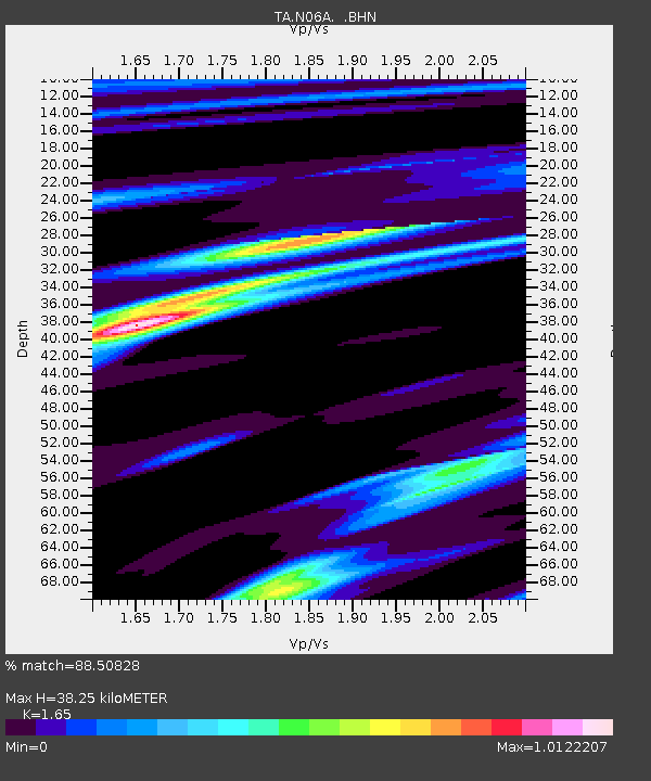
| Estimated Moho Depth: |
38.25 km |
| Estimated Crust Vp/Vs: |
1.65 |
| Assumed Crust Vp: |
6.276 km/s |
| Estimated Crust Vs: |
3.804 km/s |
| Estimated Crust Poisson's Ratio: |
0.21 |
|
| Radial Match: |
88.50828 % |
| Radial Bump: |
318 |
| Transverse Match: |
52.740387 % |
| Transverse Bump: |
400 |
| SOD ConfigId: |
2665 |
| Insert Time: |
2010-03-07 04:23:37.501 +0000 |
| GWidth: |
2.5 |
| Max Bumps: |
400 |
| Tol: |
0.001 |
|

Signal To Noise
| Channel | StoN | STA | LTA |
| TA:N06A: :BHN:20061013T13:57:17.17302Z | 1.2631712 | 1.2009069E-7 | 9.5070796E-8 |
| TA:N06A: :BHE:20061013T13:57:17.17302Z | 2.2411788 | 1.7647281E-7 | 7.8741074E-8 |
| TA:N06A: :BHZ:20061013T13:57:17.17302Z | 3.127437 | 4.1782388E-7 | 1.3359946E-7 |
| Arrivals |
| Ps | 4.2 SECOND |
| PpPs | 15 SECOND |
| PsPs/PpSs | 20 SECOND |


