You are here: Home > Network List > TA - USArray Transportable Network (new EarthScope stations) Stations List
> Station N06A Buffalo Meadows, Empire, NV, USA > Earthquake Result Viewer
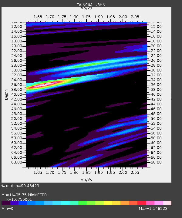
N06A Buffalo Meadows, Empire, NV, USA - Earthquake Result Viewer
| Earthquake location: |
Mariana Islands |
| Earthquake latitude/longitude: |
18.9/145.4 |
| Earthquake time(UTC): |
2007/10/31 (304) 03:30:17 GMT |
| Earthquake Depth: |
223 km |
| Earthquake Magnitude: |
6.2 MB, 7.2 MW, 7.2 MW |
| Earthquake Catalog/Contributor: |
WHDF/NEIC |
|
| Network: |
TA USArray Transportable Network (new EarthScope stations) |
| Station: |
N06A Buffalo Meadows, Empire, NV, USA |
| Lat/Lon: |
40.75 N/119.83 W |
| Elevation: |
1341 m |
|
| Distance: |
81.4 deg |
| Az: |
49.964 deg |
| Baz: |
287.425 deg |
| Ray Param: |
0.047033194 |
| Estimated Moho Depth: |
35.75 km |
| Estimated Crust Vp/Vs: |
1.68 |
| Assumed Crust Vp: |
6.276 km/s |
| Estimated Crust Vs: |
3.747 km/s |
| Estimated Crust Poisson's Ratio: |
0.22 |
|
| Radial Match: |
90.46423 % |
| Radial Bump: |
378 |
| Transverse Match: |
69.68827 % |
| Transverse Bump: |
400 |
| SOD ConfigId: |
2564 |
| Insert Time: |
2010-03-07 04:23:54.610 +0000 |
| GWidth: |
2.5 |
| Max Bumps: |
400 |
| Tol: |
0.001 |
|

Signal To Noise
| Channel | StoN | STA | LTA |
| TA:N06A: :BHN:20071031T03:41:38.399014Z | 1.7152122 | 3.5826778E-7 | 2.0887664E-7 |
| TA:N06A: :BHE:20071031T03:41:38.399014Z | 7.845608 | 1.5607731E-6 | 1.989359E-7 |
| TA:N06A: :BHZ:20071031T03:41:38.399014Z | 12.851132 | 3.8552953E-6 | 2.9999654E-7 |
| Arrivals |
| Ps | 3.9 SECOND |
| PpPs | 15 SECOND |
| PsPs/PpSs | 19 SECOND |


