You are here: Home > Network List > TA - USArray Transportable Network (new EarthScope stations) Stations List
> Station N06A Buffalo Meadows, Empire, NV, USA > Earthquake Result Viewer
N06A Buffalo Meadows, Empire, NV, USA - Earthquake Result Viewer
| Earthquake location: |
Volcano Islands, Japan Region |
| Earthquake latitude/longitude: |
22.0/142.7 |
| Earthquake time(UTC): |
2007/09/28 (271) 13:38:59 GMT |
| Earthquake Depth: |
276 km |
| Earthquake Magnitude: |
6.7 MB, 7.4 MW, 7.4 MW |
| Earthquake Catalog/Contributor: |
WHDF/NEIC |
|
| Network: |
TA USArray Transportable Network (new EarthScope stations) |
| Station: |
N06A Buffalo Meadows, Empire, NV, USA |
| Lat/Lon: |
40.75 N/119.83 W |
| Elevation: |
1341 m |
|
| Distance: |
81.4 deg |
| Az: |
49.627 deg |
| Baz: |
291.473 deg |
| Ray Param: |
0.046916336 |
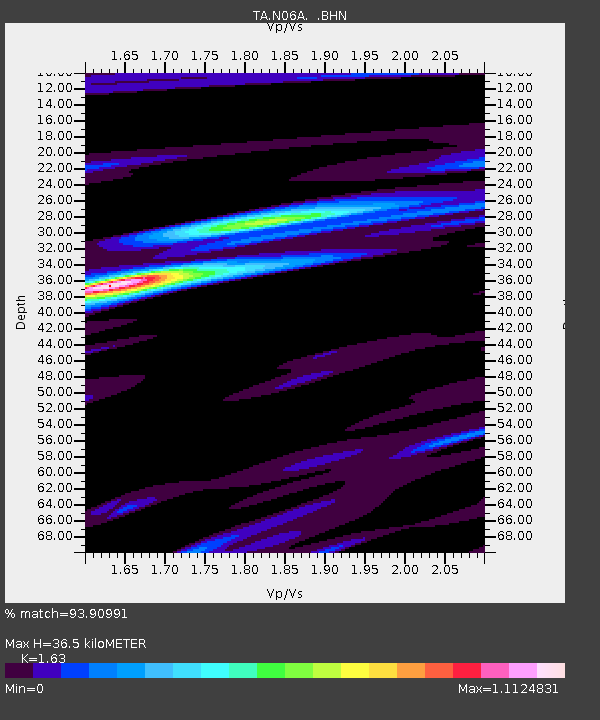
| Estimated Moho Depth: |
36.5 km |
| Estimated Crust Vp/Vs: |
1.63 |
| Assumed Crust Vp: |
6.276 km/s |
| Estimated Crust Vs: |
3.85 km/s |
| Estimated Crust Poisson's Ratio: |
0.20 |
|
| Radial Match: |
93.90991 % |
| Radial Bump: |
383 |
| Transverse Match: |
85.23179 % |
| Transverse Bump: |
400 |
| SOD ConfigId: |
2564 |
| Insert Time: |
2010-03-07 04:24:00.042 +0000 |
| GWidth: |
2.5 |
| Max Bumps: |
400 |
| Tol: |
0.001 |
|

Signal To Noise
| Channel | StoN | STA | LTA |
| TA:N06A: :BHN:20070928T13:50:14.450024Z | 21.04846 | 1.7596911E-6 | 8.3601904E-8 |
| TA:N06A: :BHE:20070928T13:50:14.450024Z | 30.308237 | 4.5329175E-6 | 1.4956058E-7 |
| TA:N06A: :BHZ:20070928T13:50:14.450024Z | 84.407906 | 1.2945967E-5 | 1.5337386E-7 |
| Arrivals |
| Ps | 3.8 SECOND |
| PpPs | 15 SECOND |
| PsPs/PpSs | 19 SECOND |


