You are here: Home > Network List > TA - USArray Transportable Network (new EarthScope stations) Stations List
> Station N06A Buffalo Meadows, Empire, NV, USA > Earthquake Result Viewer
N06A Buffalo Meadows, Empire, NV, USA - Earthquake Result Viewer
| Earthquake location: |
Kermadec Islands, New Zealand |
| Earthquake latitude/longitude: |
-29.8/-178.0 |
| Earthquake time(UTC): |
2007/01/31 (031) 03:15:52 GMT |
| Earthquake Depth: |
34 km |
| Earthquake Magnitude: |
6.1 MB, 6.3 MS, 6.5 MW, 6.4 MW |
| Earthquake Catalog/Contributor: |
WHDF/NEIC |
|
| Network: |
TA USArray Transportable Network (new EarthScope stations) |
| Station: |
N06A Buffalo Meadows, Empire, NV, USA |
| Lat/Lon: |
40.75 N/119.83 W |
| Elevation: |
1341 m |
|
| Distance: |
88.4 deg |
| Az: |
40.219 deg |
| Baz: |
227.639 deg |
| Ray Param: |
0.0425362 |
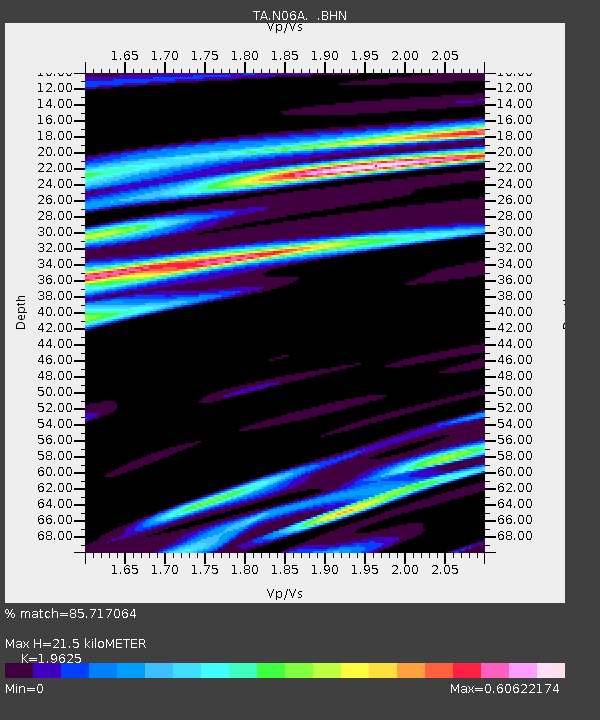
| Estimated Moho Depth: |
21.5 km |
| Estimated Crust Vp/Vs: |
1.96 |
| Assumed Crust Vp: |
6.276 km/s |
| Estimated Crust Vs: |
3.198 km/s |
| Estimated Crust Poisson's Ratio: |
0.32 |
|
| Radial Match: |
85.717064 % |
| Radial Bump: |
400 |
| Transverse Match: |
83.315895 % |
| Transverse Bump: |
387 |
| SOD ConfigId: |
2564 |
| Insert Time: |
2010-03-07 04:24:49.484 +0000 |
| GWidth: |
2.5 |
| Max Bumps: |
400 |
| Tol: |
0.001 |
|

Signal To Noise
| Channel | StoN | STA | LTA |
| TA:N06A: :BHN:20070131T03:28:09.774009Z | 0.9517545 | 2.6626773E-7 | 2.7976515E-7 |
| TA:N06A: :BHE:20070131T03:28:09.774009Z | 1.1098794 | 1.7235637E-7 | 1.5529288E-7 |
| TA:N06A: :BHZ:20070131T03:28:09.774009Z | 5.4713507 | 8.324252E-7 | 1.5214255E-7 |
| Arrivals |
| Ps | 3.4 SECOND |
| PpPs | 10.0 SECOND |
| PsPs/PpSs | 13 SECOND |


