You are here: Home > Network List > II - Global Seismograph Network (GSN - IRIS/IDA) Stations List
> Station WRAB Tennant Creek, NT, Australia > Earthquake Result Viewer
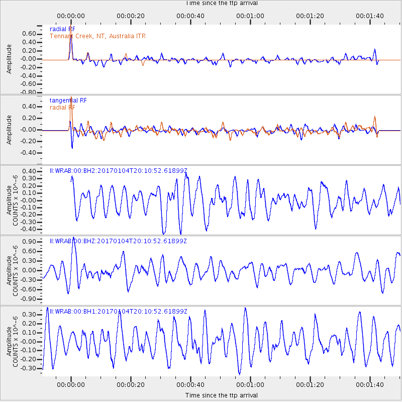
WRAB Tennant Creek, NT, Australia - Earthquake Result Viewer
*The percent match for this event was below the threshold and hence no stack was calculated.
| Earthquake location: |
Fiji Islands Region |
| Earthquake latitude/longitude: |
-18.8/176.3 |
| Earthquake time(UTC): |
2017/01/04 (004) 20:03:52 GMT |
| Earthquake Depth: |
7.0 km |
| Earthquake Magnitude: |
5.7 Mww |
| Earthquake Catalog/Contributor: |
NEIC PDE/us |
|
| Network: |
II Global Seismograph Network (GSN - IRIS/IDA) |
| Station: |
WRAB Tennant Creek, NT, Australia |
| Lat/Lon: |
19.93 S/134.36 E |
| Elevation: |
366 m |
|
| Distance: |
39.5 deg |
| Az: |
261.241 deg |
| Baz: |
95.624 deg |
| Ray Param: |
$rayparam |
*The percent match for this event was below the threshold and hence was not used in the summary stack. |
|
| Radial Match: |
66.48483 % |
| Radial Bump: |
400 |
| Transverse Match: |
38.53091 % |
| Transverse Bump: |
400 |
| SOD ConfigId: |
1943534 |
| Insert Time: |
2017-02-02 06:57:19.337 +0000 |
| GWidth: |
2.5 |
| Max Bumps: |
400 |
| Tol: |
0.001 |
|
Signal To Noise
| Channel | StoN | STA | LTA |
| II:WRAB:00:BHZ:20170104T20:10:52.61899Z | 3.1291645 | 5.2538735E-7 | 1.679002E-7 |
| II:WRAB:00:BH1:20170104T20:10:52.61899Z | 0.4970786 | 8.2715424E-8 | 1.6640311E-7 |
| II:WRAB:00:BH2:20170104T20:10:52.61899Z | 1.574862 | 2.3435899E-7 | 1.488124E-7 |
| Arrivals |
| Ps | |
| PpPs | |
| PsPs/PpSs | |


