You are here: Home > Network List > TA - USArray Transportable Network (new EarthScope stations) Stations List
> Station N25A Grover, CO, USA > Earthquake Result Viewer
N25A Grover, CO, USA - Earthquake Result Viewer
| Earthquake location: |
Tonga Islands |
| Earthquake latitude/longitude: |
-21.9/-173.8 |
| Earthquake time(UTC): |
2008/10/19 (293) 05:10:33 GMT |
| Earthquake Depth: |
29 km |
| Earthquake Magnitude: |
6.8 MB, 7.0 MS, 6.9 MW, 6.9 MW |
| Earthquake Catalog/Contributor: |
WHDF/NEIC |
|
| Network: |
TA USArray Transportable Network (new EarthScope stations) |
| Station: |
N25A Grover, CO, USA |
| Lat/Lon: |
40.81 N/104.09 W |
| Elevation: |
1607 m |
|
| Distance: |
89.8 deg |
| Az: |
45.399 deg |
| Baz: |
240.624 deg |
| Ray Param: |
0.041714422 |
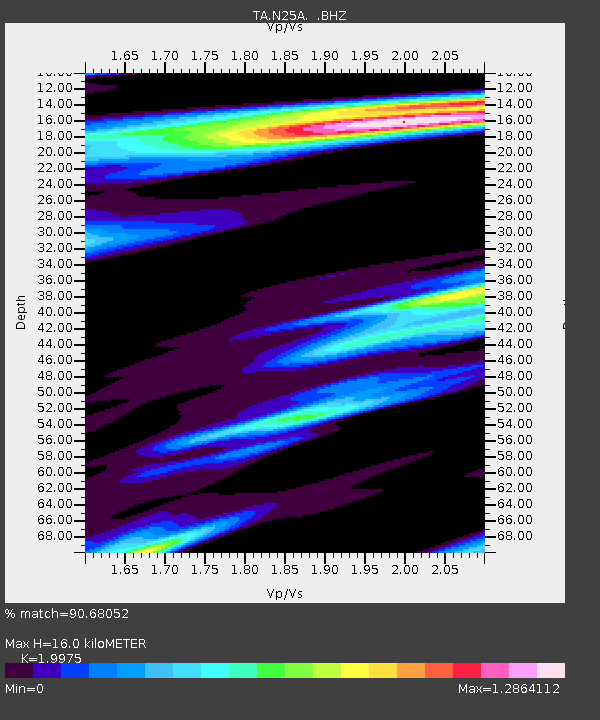
| Estimated Moho Depth: |
16.0 km |
| Estimated Crust Vp/Vs: |
2.00 |
| Assumed Crust Vp: |
6.306 km/s |
| Estimated Crust Vs: |
3.157 km/s |
| Estimated Crust Poisson's Ratio: |
0.33 |
|
| Radial Match: |
90.68052 % |
| Radial Bump: |
353 |
| Transverse Match: |
81.58152 % |
| Transverse Bump: |
400 |
| SOD ConfigId: |
2556 |
| Insert Time: |
2010-03-07 04:25:03.868 +0000 |
| GWidth: |
2.5 |
| Max Bumps: |
400 |
| Tol: |
0.001 |
|
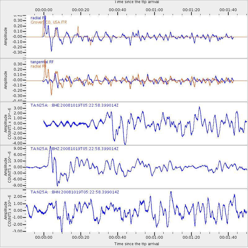
Signal To Noise
| Channel | StoN | STA | LTA |
| TA:N25A: :BHZ:20081019T05:22:58.399014Z | 23.700424 | 4.4985604E-6 | 1.8980927E-7 |
| TA:N25A: :BHN:20081019T05:22:58.399014Z | 1.6052519 | 7.2561613E-7 | 4.5202634E-7 |
| TA:N25A: :BHE:20081019T05:22:58.399014Z | 3.5100493 | 1.0398397E-6 | 2.962465E-7 |
| Arrivals |
| Ps | 2.6 SECOND |
| PpPs | 7.5 SECOND |
| PsPs/PpSs | 10 SECOND |


