You are here: Home > Network List > TA - USArray Transportable Network (new EarthScope stations) Stations List
> Station N25A Grover, CO, USA > Earthquake Result Viewer
N25A Grover, CO, USA - Earthquake Result Viewer
| Earthquake location: |
Vanuatu Islands |
| Earthquake latitude/longitude: |
-13.5/167.0 |
| Earthquake time(UTC): |
2008/09/08 (252) 18:52:06 GMT |
| Earthquake Depth: |
110 km |
| Earthquake Magnitude: |
6.4 MB, 6.9 MW, 6.9 MW |
| Earthquake Catalog/Contributor: |
WHDF/NEIC |
|
| Network: |
TA USArray Transportable Network (new EarthScope stations) |
| Station: |
N25A Grover, CO, USA |
| Lat/Lon: |
40.81 N/104.09 W |
| Elevation: |
1607 m |
|
| Distance: |
97.9 deg |
| Az: |
50.01 deg |
| Baz: |
259.075 deg |
| Ray Param: |
0.039979067 |
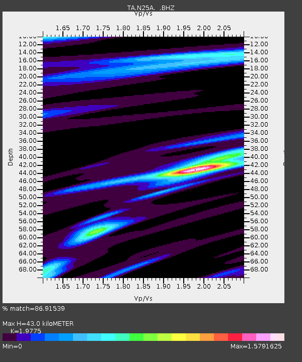
| Estimated Moho Depth: |
43.0 km |
| Estimated Crust Vp/Vs: |
1.98 |
| Assumed Crust Vp: |
6.306 km/s |
| Estimated Crust Vs: |
3.189 km/s |
| Estimated Crust Poisson's Ratio: |
0.33 |
|
| Radial Match: |
86.91539 % |
| Radial Bump: |
376 |
| Transverse Match: |
63.7115 % |
| Transverse Bump: |
400 |
| SOD ConfigId: |
2560 |
| Insert Time: |
2010-03-07 04:25:05.538 +0000 |
| GWidth: |
2.5 |
| Max Bumps: |
400 |
| Tol: |
0.001 |
|

Signal To Noise
| Channel | StoN | STA | LTA |
| TA:N25A: :BHZ:20080908T19:04:58.824004Z | 7.3111277 | 1.6435879E-6 | 2.2480634E-7 |
| TA:N25A: :BHN:20080908T19:04:58.824004Z | 2.2209413 | 3.767835E-7 | 1.6965036E-7 |
| TA:N25A: :BHE:20080908T19:04:58.824004Z | 1.9563986 | 5.6810313E-7 | 2.9038208E-7 |
| Arrivals |
| Ps | 6.8 SECOND |
| PpPs | 20 SECOND |
| PsPs/PpSs | 27 SECOND |


