You are here: Home > Network List > TA - USArray Transportable Network (new EarthScope stations) Stations List
> Station N25A Grover, CO, USA > Earthquake Result Viewer
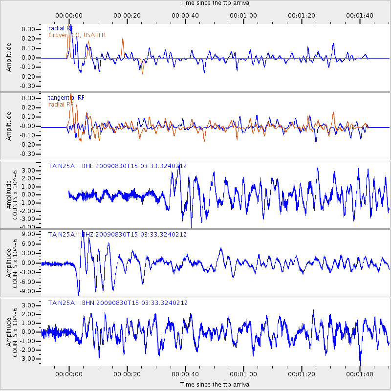
N25A Grover, CO, USA - Earthquake Result Viewer
| Earthquake location: |
Samoa Islands Region |
| Earthquake latitude/longitude: |
-15.2/-172.6 |
| Earthquake time(UTC): |
2009/08/30 (242) 14:51:32 GMT |
| Earthquake Depth: |
11 km |
| Earthquake Magnitude: |
6.4 MB, 6.3 MS, 6.6 MW, 6.6 MW |
| Earthquake Catalog/Contributor: |
WHDF/NEIC |
|
| Network: |
TA USArray Transportable Network (new EarthScope stations) |
| Station: |
N25A Grover, CO, USA |
| Lat/Lon: |
40.81 N/104.09 W |
| Elevation: |
1607 m |
|
| Distance: |
84.3 deg |
| Az: |
45.202 deg |
| Baz: |
244.489 deg |
| Ray Param: |
0.045560904 |
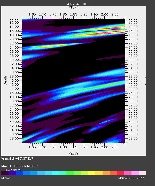
| Estimated Moho Depth: |
16.0 km |
| Estimated Crust Vp/Vs: |
2.10 |
| Assumed Crust Vp: |
6.306 km/s |
| Estimated Crust Vs: |
3.006 km/s |
| Estimated Crust Poisson's Ratio: |
0.35 |
|
| Radial Match: |
87.37317 % |
| Radial Bump: |
400 |
| Transverse Match: |
80.44954 % |
| Transverse Bump: |
400 |
| SOD ConfigId: |
2622 |
| Insert Time: |
2010-03-07 04:25:14.452 +0000 |
| GWidth: |
2.5 |
| Max Bumps: |
400 |
| Tol: |
0.001 |
|
Signal To Noise
| Channel | StoN | STA | LTA |
| TA:N25A: :BHZ:20090830T15:03:33.324021Z | 16.33896 | 4.5509655E-6 | 2.7853457E-7 |
| TA:N25A: :BHN:20090830T15:03:33.324021Z | 1.3647186 | 5.883509E-7 | 4.3111515E-7 |
| TA:N25A: :BHE:20090830T15:03:33.324021Z | 2.3654633 | 8.241369E-7 | 3.4840403E-7 |
| Arrivals |
| Ps | 2.8 SECOND |
| PpPs | 7.7 SECOND |
| PsPs/PpSs | 11 SECOND |


