You are here: Home > Network List > TA - USArray Transportable Network (new EarthScope stations) Stations List
> Station N25A Grover, CO, USA > Earthquake Result Viewer
N25A Grover, CO, USA - Earthquake Result Viewer
| Earthquake location: |
Kermadec Islands Region |
| Earthquake latitude/longitude: |
-27.4/-176.3 |
| Earthquake time(UTC): |
2009/02/18 (049) 21:53:45 GMT |
| Earthquake Depth: |
25 km |
| Earthquake Magnitude: |
6.8 MB, 7.2 MS, 6.9 MW, 6.9 MW |
| Earthquake Catalog/Contributor: |
WHDF/NEIC |
|
| Network: |
TA USArray Transportable Network (new EarthScope stations) |
| Station: |
N25A Grover, CO, USA |
| Lat/Lon: |
40.81 N/104.09 W |
| Elevation: |
1607 m |
|
| Distance: |
95.3 deg |
| Az: |
46.549 deg |
| Baz: |
238.231 deg |
| Ray Param: |
0.040807575 |
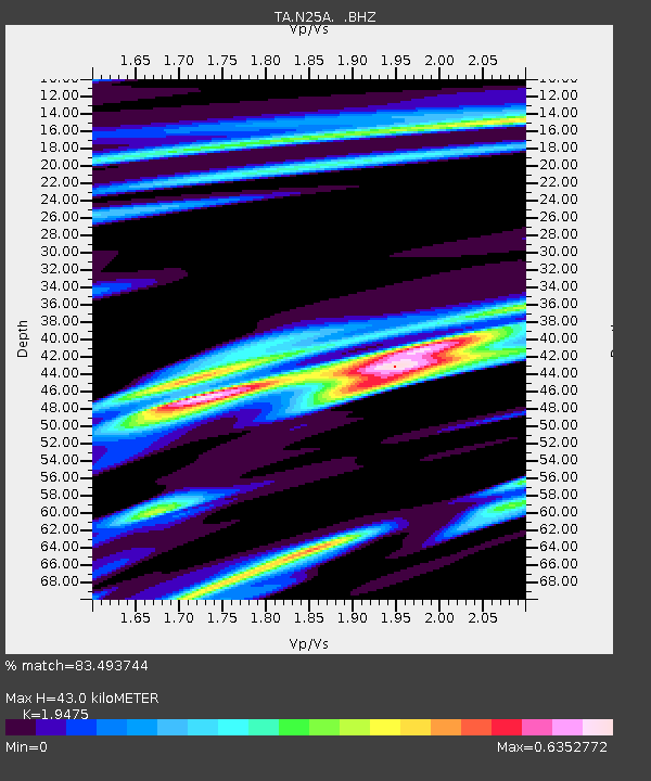
| Estimated Moho Depth: |
43.0 km |
| Estimated Crust Vp/Vs: |
1.95 |
| Assumed Crust Vp: |
6.306 km/s |
| Estimated Crust Vs: |
3.238 km/s |
| Estimated Crust Poisson's Ratio: |
0.32 |
|
| Radial Match: |
83.493744 % |
| Radial Bump: |
276 |
| Transverse Match: |
75.47918 % |
| Transverse Bump: |
318 |
| SOD ConfigId: |
2658 |
| Insert Time: |
2010-03-07 04:25:20.296 +0000 |
| GWidth: |
2.5 |
| Max Bumps: |
400 |
| Tol: |
0.001 |
|
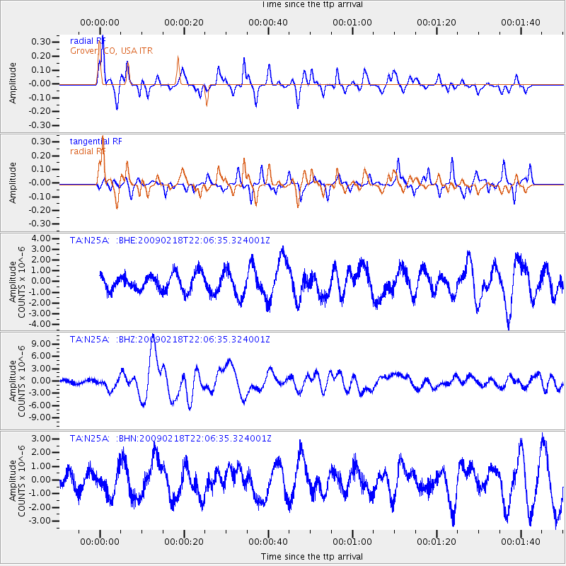
Signal To Noise
| Channel | StoN | STA | LTA |
| TA:N25A: :BHZ:20090218T22:06:35.324001Z | 4.0296197 | 1.4077847E-6 | 3.4935923E-7 |
| TA:N25A: :BHN:20090218T22:06:35.324001Z | 1.1206245 | 9.116736E-7 | 8.135407E-7 |
| TA:N25A: :BHE:20090218T22:06:35.324001Z | 1.6047047 | 1.2029853E-6 | 7.496615E-7 |
| Arrivals |
| Ps | 6.6 SECOND |
| PpPs | 20 SECOND |
| PsPs/PpSs | 26 SECOND |


