You are here: Home > Network List > TA - USArray Transportable Network (new EarthScope stations) Stations List
> Station N25A Grover, CO, USA > Earthquake Result Viewer
N25A Grover, CO, USA - Earthquake Result Viewer
| Earthquake location: |
Near Coast Of Central Chile |
| Earthquake latitude/longitude: |
-32.5/-71.7 |
| Earthquake time(UTC): |
2008/12/18 (353) 21:19:28 GMT |
| Earthquake Depth: |
18 km |
| Earthquake Magnitude: |
5.8 MB, 6.0 MS, 6.2 MW, 6.1 MW |
| Earthquake Catalog/Contributor: |
WHDF/NEIC |
|
| Network: |
TA USArray Transportable Network (new EarthScope stations) |
| Station: |
N25A Grover, CO, USA |
| Lat/Lon: |
40.81 N/104.09 W |
| Elevation: |
1607 m |
|
| Distance: |
78.8 deg |
| Az: |
335.534 deg |
| Baz: |
152.529 deg |
| Ray Param: |
0.04938263 |
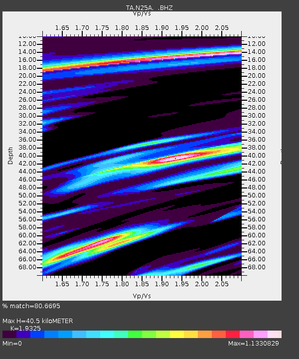
| Estimated Moho Depth: |
40.5 km |
| Estimated Crust Vp/Vs: |
1.93 |
| Assumed Crust Vp: |
6.306 km/s |
| Estimated Crust Vs: |
3.263 km/s |
| Estimated Crust Poisson's Ratio: |
0.32 |
|
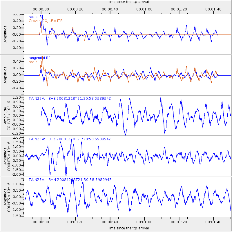
| Radial Match: |
80.6695 % |
| Radial Bump: |
400 |
| Transverse Match: |
66.536674 % |
| Transverse Bump: |
398 |
| SOD ConfigId: |
2658 |
| Insert Time: |
2010-03-07 04:25:25.005 +0000 |
| GWidth: |
2.5 |
| Max Bumps: |
400 |
| Tol: |
0.001 |
|
Signal To Noise
| Channel | StoN | STA | LTA |
| TA:N25A: :BHZ:20081218T21:30:58.598994Z | 2.3398862 | 5.1136044E-7 | 2.1854075E-7 |
| TA:N25A: :BHN:20081218T21:30:58.598994Z | 1.010009 | 4.086347E-7 | 4.0458517E-7 |
| TA:N25A: :BHE:20081218T21:30:58.598994Z | 0.77561486 | 2.7912859E-7 | 3.598804E-7 |
| Arrivals |
| Ps | 6.1 SECOND |
| PpPs | 18 SECOND |
| PsPs/PpSs | 24 SECOND |


