You are here: Home > Network List > TA - USArray Transportable Network (new EarthScope stations) Stations List
> Station N25A Grover, CO, USA > Earthquake Result Viewer
N25A Grover, CO, USA - Earthquake Result Viewer
| Earthquake location: |
Baffin Bay |
| Earthquake latitude/longitude: |
75.4/-72.5 |
| Earthquake time(UTC): |
2009/07/07 (188) 19:11:46 GMT |
| Earthquake Depth: |
19 km |
| Earthquake Magnitude: |
5.9 MB, 5.7 MS, 6.1 MW, 6.0 MW |
| Earthquake Catalog/Contributor: |
WHDF/NEIC |
|
| Network: |
TA USArray Transportable Network (new EarthScope stations) |
| Station: |
N25A Grover, CO, USA |
| Lat/Lon: |
40.81 N/104.09 W |
| Elevation: |
1607 m |
|
| Distance: |
37.4 deg |
| Az: |
220.919 deg |
| Baz: |
12.687 deg |
| Ray Param: |
0.07611869 |
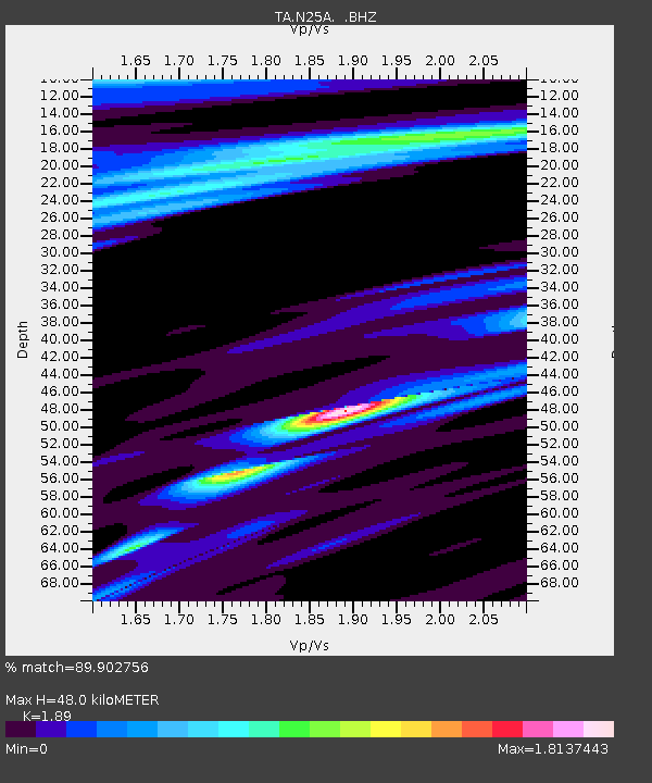
| Estimated Moho Depth: |
48.0 km |
| Estimated Crust Vp/Vs: |
1.89 |
| Assumed Crust Vp: |
6.306 km/s |
| Estimated Crust Vs: |
3.337 km/s |
| Estimated Crust Poisson's Ratio: |
0.31 |
|
| Radial Match: |
89.902756 % |
| Radial Bump: |
400 |
| Transverse Match: |
67.14016 % |
| Transverse Bump: |
400 |
| SOD ConfigId: |
2648 |
| Insert Time: |
2010-03-07 04:25:31.444 +0000 |
| GWidth: |
2.5 |
| Max Bumps: |
400 |
| Tol: |
0.001 |
|
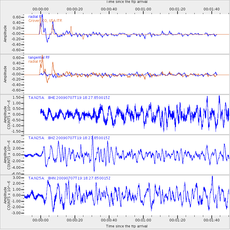
Signal To Noise
| Channel | StoN | STA | LTA |
| TA:N25A: :BHZ:20090707T19:18:27.850015Z | 7.468879 | 1.8019972E-6 | 2.412674E-7 |
| TA:N25A: :BHN:20090707T19:18:27.850015Z | 3.3066487 | 1.0520143E-6 | 3.1815125E-7 |
| TA:N25A: :BHE:20090707T19:18:27.850015Z | 1.1712769 | 3.0668642E-7 | 2.6183938E-7 |
| Arrivals |
| Ps | 7.2 SECOND |
| PpPs | 21 SECOND |
| PsPs/PpSs | 28 SECOND |


