You are here: Home > Network List > TA - USArray Transportable Network (new EarthScope stations) Stations List
> Station N25A Grover, CO, USA > Earthquake Result Viewer
N25A Grover, CO, USA - Earthquake Result Viewer
| Earthquake location: |
Off Coast Of Ecuador |
| Earthquake latitude/longitude: |
1.4/-85.2 |
| Earthquake time(UTC): |
2009/05/10 (130) 01:16:06 GMT |
| Earthquake Depth: |
6.0 km |
| Earthquake Magnitude: |
5.5 MB, 5.7 MS, 6.1 MW, 6.1 MW |
| Earthquake Catalog/Contributor: |
WHDF/NEIC |
|
| Network: |
TA USArray Transportable Network (new EarthScope stations) |
| Station: |
N25A Grover, CO, USA |
| Lat/Lon: |
40.81 N/104.09 W |
| Elevation: |
1607 m |
|
| Distance: |
42.8 deg |
| Az: |
338.773 deg |
| Baz: |
151.518 deg |
| Ray Param: |
0.07295737 |
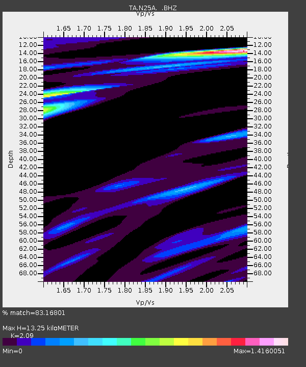
| Estimated Moho Depth: |
13.25 km |
| Estimated Crust Vp/Vs: |
2.09 |
| Assumed Crust Vp: |
6.306 km/s |
| Estimated Crust Vs: |
3.017 km/s |
| Estimated Crust Poisson's Ratio: |
0.35 |
|
| Radial Match: |
83.16801 % |
| Radial Bump: |
383 |
| Transverse Match: |
55.228184 % |
| Transverse Bump: |
358 |
| SOD ConfigId: |
2760 |
| Insert Time: |
2010-03-07 04:25:34.769 +0000 |
| GWidth: |
2.5 |
| Max Bumps: |
400 |
| Tol: |
0.001 |
|
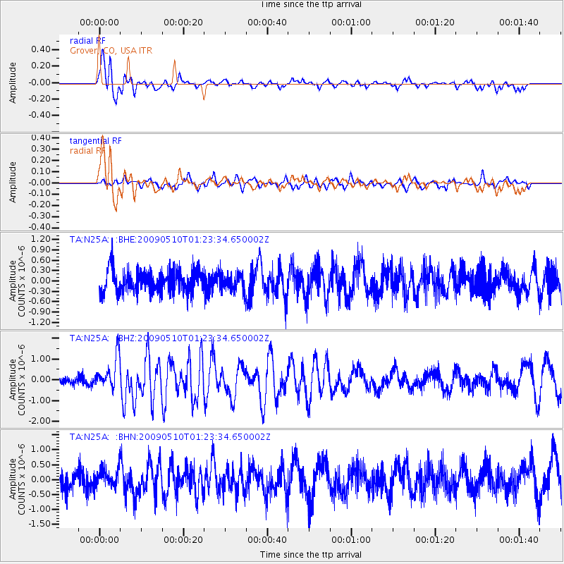
Signal To Noise
| Channel | StoN | STA | LTA |
| TA:N25A: :BHZ:20090510T01:23:34.650002Z | 4.4795485 | 8.0471216E-7 | 1.7964135E-7 |
| TA:N25A: :BHN:20090510T01:23:34.650002Z | 1.1171262 | 3.1771086E-7 | 2.8440013E-7 |
| TA:N25A: :BHE:20090510T01:23:34.650002Z | 0.75136185 | 2.4470913E-7 | 3.2568747E-7 |
| Arrivals |
| Ps | 2.4 SECOND |
| PpPs | 6.1 SECOND |
| PsPs/PpSs | 8.6 SECOND |


