You are here: Home > Network List > TA - USArray Transportable Network (new EarthScope stations) Stations List
> Station C16K Lisburne Hills, AK, USA > Earthquake Result Viewer
C16K Lisburne Hills, AK, USA - Earthquake Result Viewer
| Earthquake location: |
Halmahera, Indonesia |
| Earthquake latitude/longitude: |
-1.0/128.5 |
| Earthquake time(UTC): |
2019/09/14 (257) 16:21:29 GMT |
| Earthquake Depth: |
10 km |
| Earthquake Magnitude: |
5.9 Mww |
| Earthquake Catalog/Contributor: |
NEIC PDE/us |
|
| Network: |
TA USArray Transportable Network (new EarthScope stations) |
| Station: |
C16K Lisburne Hills, AK, USA |
| Lat/Lon: |
68.27 N/165.34 W |
| Elevation: |
102 m |
|
| Distance: |
82.2 deg |
| Az: |
20.094 deg |
| Baz: |
247.318 deg |
| Ray Param: |
0.047028508 |
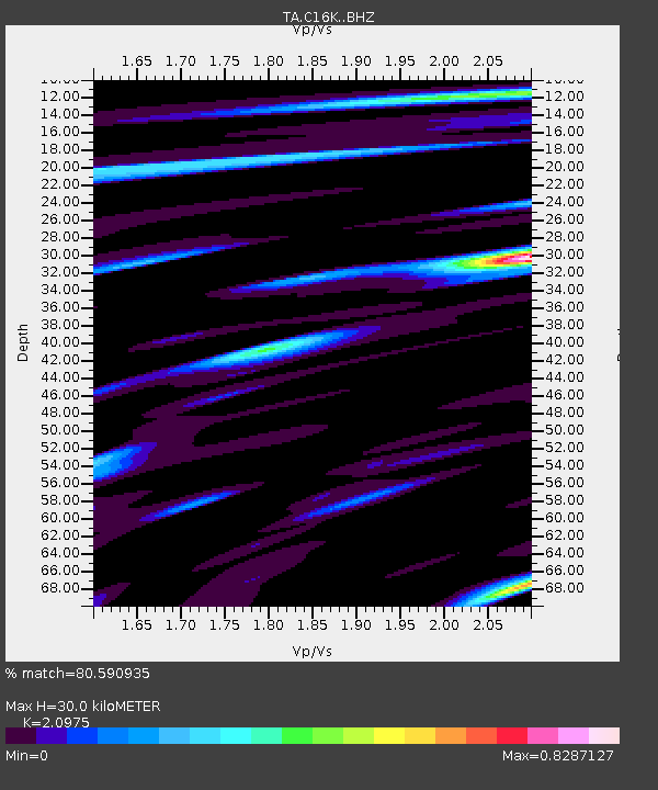
| Estimated Moho Depth: |
30.0 km |
| Estimated Crust Vp/Vs: |
2.10 |
| Assumed Crust Vp: |
5.906 km/s |
| Estimated Crust Vs: |
2.816 km/s |
| Estimated Crust Poisson's Ratio: |
0.35 |
|
| Radial Match: |
80.590935 % |
| Radial Bump: |
400 |
| Transverse Match: |
62.111774 % |
| Transverse Bump: |
400 |
| SOD ConfigId: |
19053131 |
| Insert Time: |
2019-09-28 16:26:30.773 +0000 |
| GWidth: |
2.5 |
| Max Bumps: |
400 |
| Tol: |
0.001 |
|
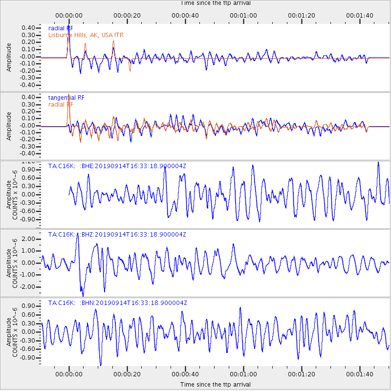
Signal To Noise
| Channel | StoN | STA | LTA |
| TA:C16K: :BHZ:20190914T16:33:18.900004Z | 4.2900276 | 1.3539105E-6 | 3.155948E-7 |
| TA:C16K: :BHN:20190914T16:33:18.900004Z | 1.4451205 | 3.8134093E-7 | 2.6388176E-7 |
| TA:C16K: :BHE:20190914T16:33:18.900004Z | 2.0846853 | 4.881077E-7 | 2.3413975E-7 |
| Arrivals |
| Ps | 5.7 SECOND |
| PpPs | 15 SECOND |
| PsPs/PpSs | 21 SECOND |


