You are here: Home > Network List > TA - USArray Transportable Network (new EarthScope stations) Stations List
> Station D17K Noatak River, AK, USA > Earthquake Result Viewer
D17K Noatak River, AK, USA - Earthquake Result Viewer
| Earthquake location: |
Halmahera, Indonesia |
| Earthquake latitude/longitude: |
-1.0/128.5 |
| Earthquake time(UTC): |
2019/09/14 (257) 16:21:29 GMT |
| Earthquake Depth: |
10 km |
| Earthquake Magnitude: |
5.9 Mww |
| Earthquake Catalog/Contributor: |
NEIC PDE/us |
|
| Network: |
TA USArray Transportable Network (new EarthScope stations) |
| Station: |
D17K Noatak River, AK, USA |
| Lat/Lon: |
67.70 N/163.08 W |
| Elevation: |
172 m |
|
| Distance: |
82.8 deg |
| Az: |
20.953 deg |
| Baz: |
249.524 deg |
| Ray Param: |
0.04662615 |
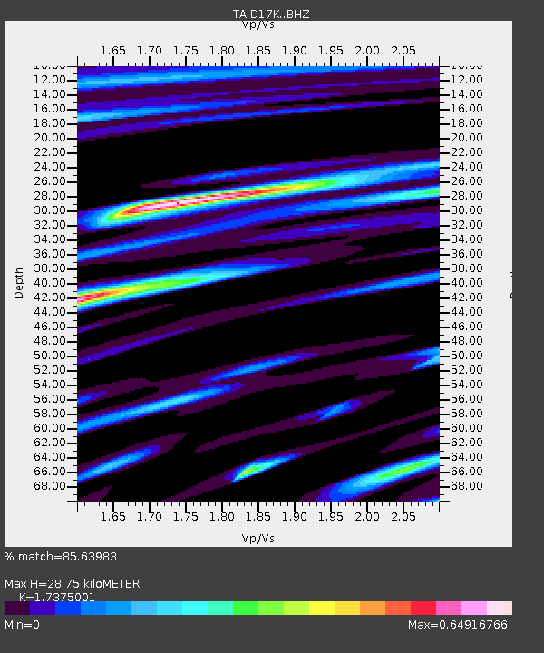
| Estimated Moho Depth: |
28.75 km |
| Estimated Crust Vp/Vs: |
1.74 |
| Assumed Crust Vp: |
6.276 km/s |
| Estimated Crust Vs: |
3.612 km/s |
| Estimated Crust Poisson's Ratio: |
0.25 |
|
| Radial Match: |
85.63983 % |
| Radial Bump: |
394 |
| Transverse Match: |
80.48586 % |
| Transverse Bump: |
358 |
| SOD ConfigId: |
19053131 |
| Insert Time: |
2019-09-28 16:26:35.303 +0000 |
| GWidth: |
2.5 |
| Max Bumps: |
400 |
| Tol: |
0.001 |
|

Signal To Noise
| Channel | StoN | STA | LTA |
| TA:D17K: :BHZ:20190914T16:33:21.900004Z | 10.25423 | 1.0694833E-6 | 1.04296795E-7 |
| TA:D17K: :BHN:20190914T16:33:21.900004Z | 2.296517 | 2.5934492E-7 | 1.12929676E-7 |
| TA:D17K: :BHE:20190914T16:33:21.900004Z | 1.9864657 | 3.094913E-7 | 1.5579997E-7 |
| Arrivals |
| Ps | 3.5 SECOND |
| PpPs | 12 SECOND |
| PsPs/PpSs | 16 SECOND |


