You are here: Home > Network List > TA - USArray Transportable Network (new EarthScope stations) Stations List
> Station E18K Tukpahlearik Creek, AK, USA > Earthquake Result Viewer
E18K Tukpahlearik Creek, AK, USA - Earthquake Result Viewer

| Earthquake location: |
Halmahera, Indonesia |
| Earthquake latitude/longitude: |
-1.0/128.5 |
| Earthquake time(UTC): |
2019/09/14 (257) 16:21:29 GMT |
| Earthquake Depth: |
10 km |
| Earthquake Magnitude: |
5.9 Mww |
| Earthquake Catalog/Contributor: |
NEIC PDE/us |
|
| Network: |
TA USArray Transportable Network (new EarthScope stations) |
| Station: |
E18K Tukpahlearik Creek, AK, USA |
| Lat/Lon: |
67.42 N/160.60 W |
| Elevation: |
297 m |
|
| Distance: |
83.6 deg |
| Az: |
21.535 deg |
| Baz: |
251.883 deg |
| Ray Param: |
0.04605831 |
| Estimated Moho Depth: |
27.25 km |
| Estimated Crust Vp/Vs: |
1.88 |
| Assumed Crust Vp: |
6.276 km/s |
| Estimated Crust Vs: |
3.347 km/s |
| Estimated Crust Poisson's Ratio: |
0.30 |
|
| Radial Match: |
80.4186 % |
| Radial Bump: |
400 |
| Transverse Match: |
78.98387 % |
| Transverse Bump: |
400 |
| SOD ConfigId: |
19053131 |
| Insert Time: |
2019-09-28 16:26:40.483 +0000 |
| GWidth: |
2.5 |
| Max Bumps: |
400 |
| Tol: |
0.001 |
|
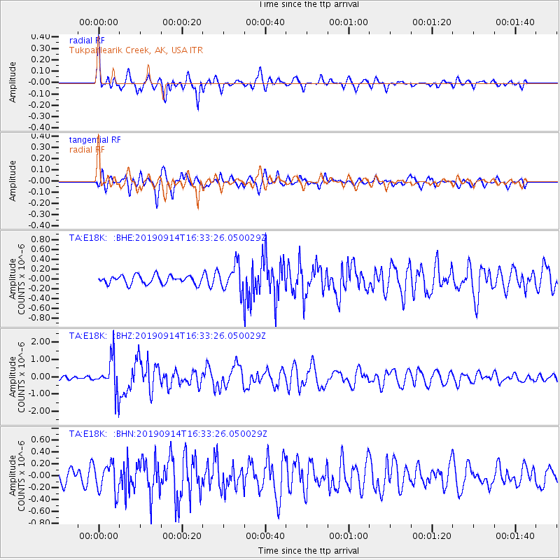
Signal To Noise
| Channel | StoN | STA | LTA |
| TA:E18K: :BHZ:20190914T16:33:26.050029Z | 9.89532 | 1.0119251E-6 | 1.0226299E-7 |
| TA:E18K: :BHN:20190914T16:33:26.050029Z | 2.7104757 | 2.4442699E-7 | 9.017863E-8 |
| TA:E18K: :BHE:20190914T16:33:26.050029Z | 3.1418717 | 2.689116E-7 | 8.558962E-8 |
| Arrivals |
| Ps | 3.9 SECOND |
| PpPs | 12 SECOND |
| PsPs/PpSs | 16 SECOND |


