You are here: Home > Network List > TA - USArray Transportable Network (new EarthScope stations) Stations List
> Station F20K Avaraart Lake, AK, USA > Earthquake Result Viewer
F20K Avaraart Lake, AK, USA - Earthquake Result Viewer

| Earthquake location: |
Halmahera, Indonesia |
| Earthquake latitude/longitude: |
-1.0/128.5 |
| Earthquake time(UTC): |
2019/09/14 (257) 16:21:29 GMT |
| Earthquake Depth: |
10 km |
| Earthquake Magnitude: |
5.9 Mww |
| Earthquake Catalog/Contributor: |
NEIC PDE/us |
|
| Network: |
TA USArray Transportable Network (new EarthScope stations) |
| Station: |
F20K Avaraart Lake, AK, USA |
| Lat/Lon: |
67.05 N/155.73 W |
| Elevation: |
136 m |
|
| Distance: |
85.3 deg |
| Az: |
22.416 deg |
| Baz: |
256.461 deg |
| Ray Param: |
0.04483163 |
| Estimated Moho Depth: |
24.25 km |
| Estimated Crust Vp/Vs: |
1.81 |
| Assumed Crust Vp: |
6.522 km/s |
| Estimated Crust Vs: |
3.598 km/s |
| Estimated Crust Poisson's Ratio: |
0.28 |
|
| Radial Match: |
84.39001 % |
| Radial Bump: |
400 |
| Transverse Match: |
70.79966 % |
| Transverse Bump: |
400 |
| SOD ConfigId: |
19053131 |
| Insert Time: |
2019-09-28 16:26:49.262 +0000 |
| GWidth: |
2.5 |
| Max Bumps: |
400 |
| Tol: |
0.001 |
|
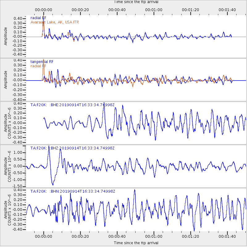
Signal To Noise
| Channel | StoN | STA | LTA |
| TA:F20K: :BHZ:20190914T16:33:34.74998Z | 7.7894106 | 6.6369756E-7 | 8.52051E-8 |
| TA:F20K: :BHN:20190914T16:33:34.74998Z | 0.53011775 | 4.996272E-8 | 9.424834E-8 |
| TA:F20K: :BHE:20190914T16:33:34.74998Z | 2.9236755 | 1.8366973E-7 | 6.282151E-8 |
| Arrivals |
| Ps | 3.1 SECOND |
| PpPs | 10 SECOND |
| PsPs/PpSs | 13 SECOND |


