You are here: Home > Network List > TA - USArray Transportable Network (new EarthScope stations) Stations List
> Station N25A Grover, CO, USA > Earthquake Result Viewer
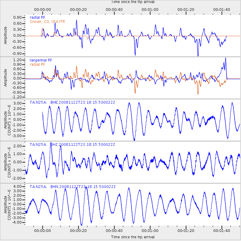
N25A Grover, CO, USA - Earthquake Result Viewer
*The percent match for this event was below the threshold and hence no stack was calculated.
| Earthquake location: |
Southeast Of Easter Island |
| Earthquake latitude/longitude: |
-37.2/-95.1 |
| Earthquake time(UTC): |
2008/11/22 (327) 23:06:47 GMT |
| Earthquake Depth: |
10 km |
| Earthquake Magnitude: |
5.6 MB, 5.3 MS, 5.7 MW, 5.7 MW |
| Earthquake Catalog/Contributor: |
WHDF/NEIC |
|
| Network: |
TA USArray Transportable Network (new EarthScope stations) |
| Station: |
N25A Grover, CO, USA |
| Lat/Lon: |
40.81 N/104.09 W |
| Elevation: |
1607 m |
|
| Distance: |
78.1 deg |
| Az: |
353.014 deg |
| Baz: |
172.653 deg |
| Ray Param: |
$rayparam |
*The percent match for this event was below the threshold and hence was not used in the summary stack. |
|
| Radial Match: |
73.49587 % |
| Radial Bump: |
341 |
| Transverse Match: |
62.122074 % |
| Transverse Bump: |
380 |
| SOD ConfigId: |
2658 |
| Insert Time: |
2010-03-07 04:25:50.043 +0000 |
| GWidth: |
2.5 |
| Max Bumps: |
400 |
| Tol: |
0.001 |
|
Signal To Noise
| Channel | StoN | STA | LTA |
| TA:N25A: :BHZ:20081122T23:18:15.500022Z | 2.1866999 | 1.229929E-6 | 5.62459E-7 |
| TA:N25A: :BHN:20081122T23:18:15.500022Z | 0.5681669 | 1.0049323E-6 | 1.7687271E-6 |
| TA:N25A: :BHE:20081122T23:18:15.500022Z | 0.6535775 | 1.0523273E-6 | 1.6101034E-6 |
| Arrivals |
| Ps | |
| PpPs | |
| PsPs/PpSs | |


