You are here: Home > Network List > TA - USArray Transportable Network (new EarthScope stations) Stations List
> Station N25A Grover, CO, USA > Earthquake Result Viewer
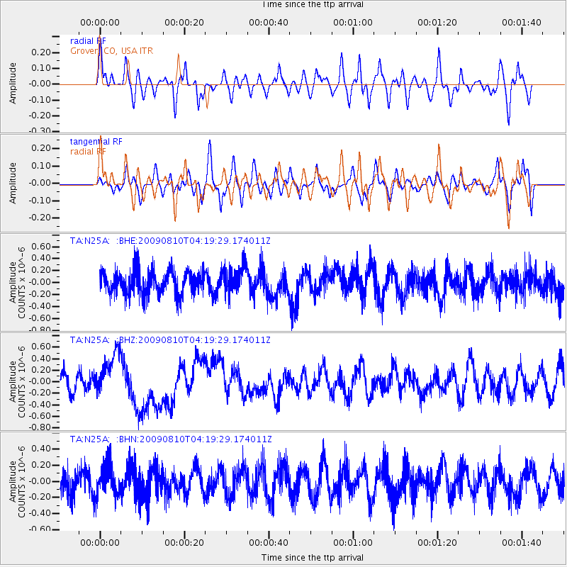
N25A Grover, CO, USA - Earthquake Result Viewer
*The percent match for this event was below the threshold and hence no stack was calculated.
| Earthquake location: |
Santa Cruz Islands |
| Earthquake latitude/longitude: |
-11.6/166.1 |
| Earthquake time(UTC): |
2009/08/10 (222) 04:06:31 GMT |
| Earthquake Depth: |
35 km |
| Earthquake Magnitude: |
5.8 MB, 6.3 MS, 6.6 MW, 6.6 MW |
| Earthquake Catalog/Contributor: |
WHDF/NEIC |
|
| Network: |
TA USArray Transportable Network (new EarthScope stations) |
| Station: |
N25A Grover, CO, USA |
| Lat/Lon: |
40.81 N/104.09 W |
| Elevation: |
1607 m |
|
| Distance: |
97.3 deg |
| Az: |
49.933 deg |
| Baz: |
261.081 deg |
| Ray Param: |
$rayparam |
*The percent match for this event was below the threshold and hence was not used in the summary stack. |
|
| Radial Match: |
58.471004 % |
| Radial Bump: |
400 |
| Transverse Match: |
44.617474 % |
| Transverse Bump: |
400 |
| SOD ConfigId: |
2622 |
| Insert Time: |
2010-03-07 04:25:51.409 +0000 |
| GWidth: |
2.5 |
| Max Bumps: |
400 |
| Tol: |
0.001 |
|
Signal To Noise
| Channel | StoN | STA | LTA |
| TA:N25A: :BHZ:20090810T04:19:29.174011Z | 2.8974724 | 3.9236417E-7 | 1.3541602E-7 |
| TA:N25A: :BHN:20090810T04:19:29.174011Z | 1.1600664 | 1.8386295E-7 | 1.5849348E-7 |
| TA:N25A: :BHE:20090810T04:19:29.174011Z | 1.1734725 | 2.3607608E-7 | 2.0117734E-7 |
| Arrivals |
| Ps | |
| PpPs | |
| PsPs/PpSs | |


