You are here: Home > Network List > TA - USArray Transportable Network (new EarthScope stations) Stations List
> Station N25A Grover, CO, USA > Earthquake Result Viewer
N25A Grover, CO, USA - Earthquake Result Viewer
*The percent match for this event was below the threshold and hence no stack was calculated.
| Earthquake location: |
Easter Island Region |
| Earthquake latitude/longitude: |
-29.9/-111.8 |
| Earthquake time(UTC): |
2009/09/10 (253) 19:46:03 GMT |
| Earthquake Depth: |
10 km |
| Earthquake Magnitude: |
5.5 MW, 5.4 MB |
| Earthquake Catalog/Contributor: |
WHDF/NEIC |
|
| Network: |
TA USArray Transportable Network (new EarthScope stations) |
| Station: |
N25A Grover, CO, USA |
| Lat/Lon: |
40.81 N/104.09 W |
| Elevation: |
1607 m |
|
| Distance: |
70.7 deg |
| Az: |
6.213 deg |
| Baz: |
187.111 deg |
| Ray Param: |
$rayparam |
*The percent match for this event was below the threshold and hence was not used in the summary stack. |
|
| Radial Match: |
67.67725 % |
| Radial Bump: |
400 |
| Transverse Match: |
53.978264 % |
| Transverse Bump: |
400 |
| SOD ConfigId: |
2622 |
| Insert Time: |
2010-03-07 04:25:54.458 +0000 |
| GWidth: |
2.5 |
| Max Bumps: |
400 |
| Tol: |
0.001 |
|
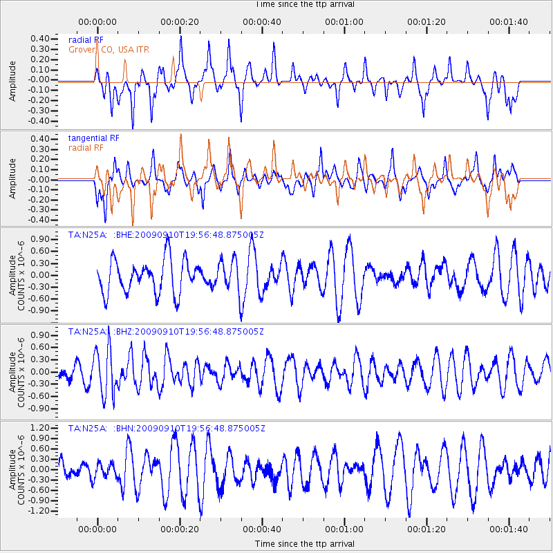
Signal To Noise
| Channel | StoN | STA | LTA |
| TA:N25A: :BHZ:20090910T19:56:48.875005Z | 2.6487503 | 5.808382E-7 | 2.1928764E-7 |
| TA:N25A: :BHN:20090910T19:56:48.875005Z | 0.6558026 | 1.983619E-7 | 3.02472E-7 |
| TA:N25A: :BHE:20090910T19:56:48.875005Z | 0.99149346 | 4.1804455E-7 | 4.2163117E-7 |
| Arrivals |
| Ps | |
| PpPs | |
| PsPs/PpSs | |


