You are here: Home > Network List > TA - USArray Transportable Network (new EarthScope stations) Stations List
> Station N25A Grover, CO, USA > Earthquake Result Viewer
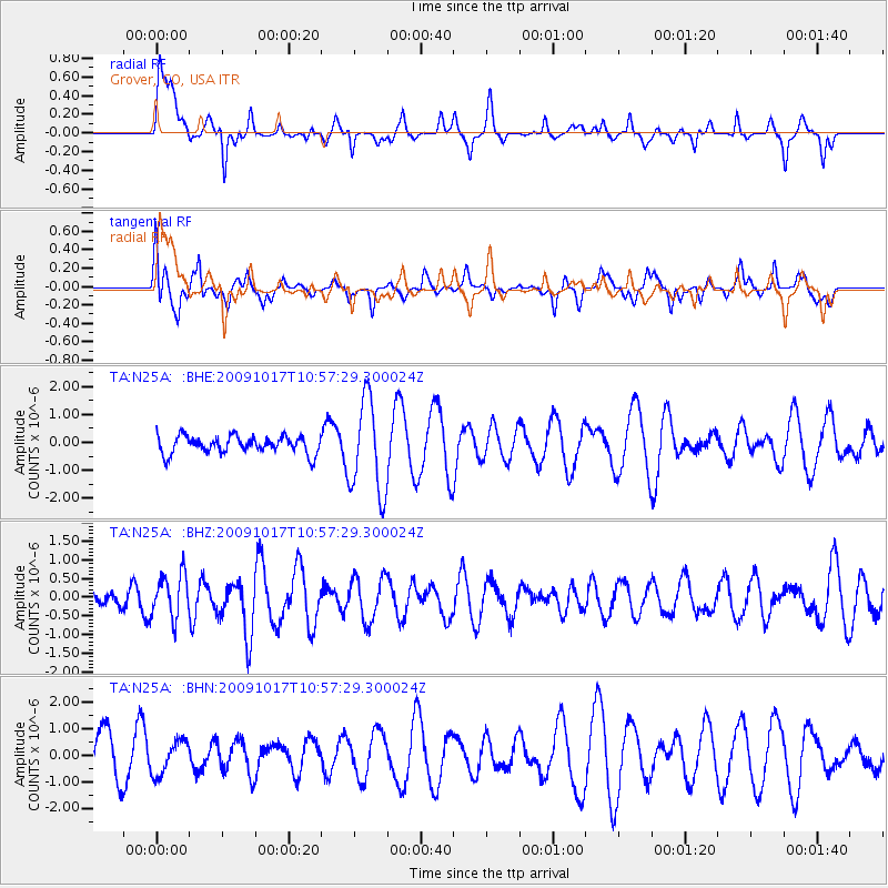
N25A Grover, CO, USA - Earthquake Result Viewer
*The percent match for this event was below the threshold and hence no stack was calculated.
| Earthquake location: |
Samoa Islands Region |
| Earthquake latitude/longitude: |
-16.4/-172.0 |
| Earthquake time(UTC): |
2009/10/17 (290) 10:45:26 GMT |
| Earthquake Depth: |
10 km |
| Earthquake Magnitude: |
5.7 MB, 5.3 MS, 5.7 MW, 5.7 MW |
| Earthquake Catalog/Contributor: |
WHDF/NEIC |
|
| Network: |
TA USArray Transportable Network (new EarthScope stations) |
| Station: |
N25A Grover, CO, USA |
| Lat/Lon: |
40.81 N/104.09 W |
| Elevation: |
1607 m |
|
| Distance: |
84.7 deg |
| Az: |
44.929 deg |
| Baz: |
243.283 deg |
| Ray Param: |
$rayparam |
*The percent match for this event was below the threshold and hence was not used in the summary stack. |
|
| Radial Match: |
47.731647 % |
| Radial Bump: |
342 |
| Transverse Match: |
32.868652 % |
| Transverse Bump: |
303 |
| SOD ConfigId: |
2622 |
| Insert Time: |
2010-03-07 04:25:57.321 +0000 |
| GWidth: |
2.5 |
| Max Bumps: |
400 |
| Tol: |
0.001 |
|
Signal To Noise
| Channel | StoN | STA | LTA |
| TA:N25A: :BHZ:20091017T10:57:29.300024Z | 1.3726449 | 5.838467E-7 | 4.2534433E-7 |
| TA:N25A: :BHN:20091017T10:57:29.300024Z | 0.88973314 | 6.271183E-7 | 7.0483867E-7 |
| TA:N25A: :BHE:20091017T10:57:29.300024Z | 5.3831205 | 1.6854799E-6 | 3.131046E-7 |
| Arrivals |
| Ps | |
| PpPs | |
| PsPs/PpSs | |


