You are here: Home > Network List > TA - USArray Transportable Network (new EarthScope stations) Stations List
> Station N25A Grover, CO, USA > Earthquake Result Viewer
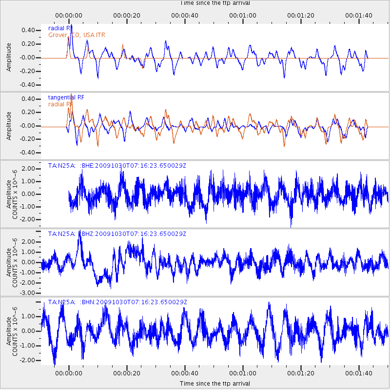
N25A Grover, CO, USA - Earthquake Result Viewer
*The percent match for this event was below the threshold and hence no stack was calculated.
| Earthquake location: |
Ryukyu Islands, Japan |
| Earthquake latitude/longitude: |
29.2/129.8 |
| Earthquake time(UTC): |
2009/10/30 (303) 07:03:39 GMT |
| Earthquake Depth: |
34 km |
| Earthquake Magnitude: |
6.3 MB, 6.8 MS, 6.8 MW, 6.8 MW |
| Earthquake Catalog/Contributor: |
WHDF/NEIC |
|
| Network: |
TA USArray Transportable Network (new EarthScope stations) |
| Station: |
N25A Grover, CO, USA |
| Lat/Lon: |
40.81 N/104.09 W |
| Elevation: |
1607 m |
|
| Distance: |
94.3 deg |
| Az: |
37.935 deg |
| Baz: |
314.925 deg |
| Ray Param: |
$rayparam |
*The percent match for this event was below the threshold and hence was not used in the summary stack. |
|
| Radial Match: |
44.676445 % |
| Radial Bump: |
400 |
| Transverse Match: |
44.026577 % |
| Transverse Bump: |
400 |
| SOD ConfigId: |
2622 |
| Insert Time: |
2010-03-07 04:26:00.261 +0000 |
| GWidth: |
2.5 |
| Max Bumps: |
400 |
| Tol: |
0.001 |
|
Signal To Noise
| Channel | StoN | STA | LTA |
| TA:N25A: :BHZ:20091030T07:16:23.650029Z | 2.766721 | 1.2715423E-6 | 4.5958456E-7 |
| TA:N25A: :BHN:20091030T07:16:23.650029Z | 0.90844226 | 6.7677263E-7 | 7.449815E-7 |
| TA:N25A: :BHE:20091030T07:16:23.650029Z | 0.7572069 | 5.552263E-7 | 7.3325566E-7 |
| Arrivals |
| Ps | |
| PpPs | |
| PsPs/PpSs | |


