You are here: Home > Network List > TA - USArray Transportable Network (new EarthScope stations) Stations List
> Station N25A Grover, CO, USA > Earthquake Result Viewer
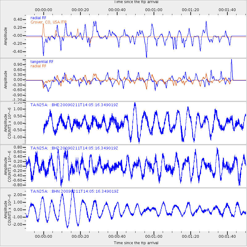
N25A Grover, CO, USA - Earthquake Result Viewer
*The percent match for this event was below the threshold and hence no stack was calculated.
| Earthquake location: |
Fiji Islands |
| Earthquake latitude/longitude: |
-16.2/178.3 |
| Earthquake time(UTC): |
2009/02/11 (042) 13:52:41 GMT |
| Earthquake Depth: |
10 km |
| Earthquake Magnitude: |
5.6 MB, 5.3 MS, 5.7 MW, 5.7 MW |
| Earthquake Catalog/Contributor: |
WHDF/NEIC |
|
| Network: |
TA USArray Transportable Network (new EarthScope stations) |
| Station: |
N25A Grover, CO, USA |
| Lat/Lon: |
40.81 N/104.09 W |
| Elevation: |
1607 m |
|
| Distance: |
91.4 deg |
| Az: |
47.857 deg |
| Baz: |
249.8 deg |
| Ray Param: |
$rayparam |
*The percent match for this event was below the threshold and hence was not used in the summary stack. |
|
| Radial Match: |
47.613758 % |
| Radial Bump: |
388 |
| Transverse Match: |
48.625866 % |
| Transverse Bump: |
353 |
| SOD ConfigId: |
2658 |
| Insert Time: |
2010-03-07 04:26:10.098 +0000 |
| GWidth: |
2.5 |
| Max Bumps: |
400 |
| Tol: |
0.001 |
|
Signal To Noise
| Channel | StoN | STA | LTA |
| TA:N25A: :BHZ:20090211T14:05:16.349019Z | 0.8747843 | 2.591203E-7 | 2.962105E-7 |
| TA:N25A: :BHN:20090211T14:05:16.349019Z | 2.424123 | 1.1746093E-6 | 4.845502E-7 |
| TA:N25A: :BHE:20090211T14:05:16.349019Z | 0.8667329 | 3.056338E-7 | 3.526274E-7 |
| Arrivals |
| Ps | |
| PpPs | |
| PsPs/PpSs | |


