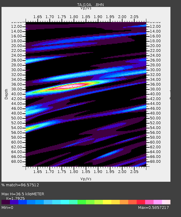
J10A Berg Farm, Melba ID, USA - Earthquake Result Viewer
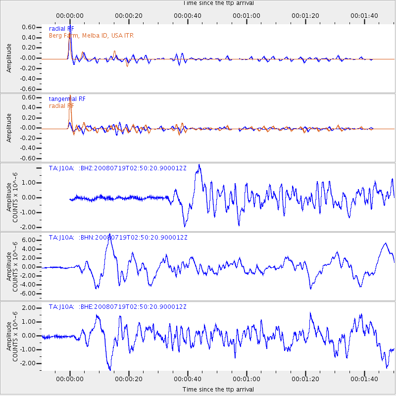
Earthquake location: Off East Coast Of Honshu, Japan
Earthquake latitude/longitude: 37.6/142.2
Earthquake time(UTC): 2008/07/19 (201) 02:39:28 GMT
Earthquake Depth: 22 km
Earthquake Magnitude: 6.2 MB, 7.0 MS, 7.0 MW, 6.9 MW
Earthquake Catalog/Contributor: WHDF/NEIC
Network: TA USArray Transportable Network (new EarthScope stations)
Station: J10A Berg Farm, Melba ID, USA
Lat/Lon: 43.43 N/116.77 W
Elevation: 748 m
Distance: 72.2 deg
Az: 48.669 deg
Baz: 304.999 deg
Ray Param: 0.053768955
Estimated Moho Depth: 36.5 km
Estimated Crust Vp/Vs: 1.79
Assumed Crust Vp: 6.291 km/s
Estimated Crust Vs: 3.51 km/s
Estimated Crust Poisson's Ratio: 0.27
Radial Match: 96.57512 %
Radial Bump: 400
Transverse Match: 82.63584 %
Transverse Bump: 400
SOD ConfigId: 2504
Insert Time: 2010-03-07 04:26:17.741 +0000
GWidth: 2.5
Max Bumps: 400
Tol: 0.001

Signal To Noise

ChannelStoNSTALTA
TA:J10A: :BHN:20080719T02:50:20.900012Z5.0129134.0472835E-78.073715E-8
TA:J10A: :BHE:20080719T02:50:20.900012Z2.99990061.9074271E-76.3583016E-8
TA:J10A: :BHZ:20080719T02:50:20.900012Z1.68900981.3572246E-78.035623E-8
Arrivals
Ps4.8 SECOND
PpPs16 SECOND
PsPs/PpSs20 SECOND