You are here: Home > Network List > G - GEOSCOPE Stations List
> Station TAOE Taiohae, Marquises islands > Earthquake Result Viewer
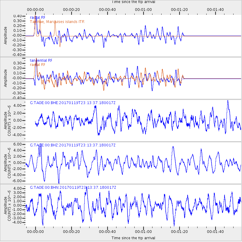
TAOE Taiohae, Marquises islands - Earthquake Result Viewer
*The percent match for this event was below the threshold and hence no stack was calculated.
| Earthquake location: |
Solomon Islands |
| Earthquake latitude/longitude: |
-10.4/161.3 |
| Earthquake time(UTC): |
2017/01/19 (019) 23:04:20 GMT |
| Earthquake Depth: |
34 km |
| Earthquake Magnitude: |
6.8 mwp |
| Earthquake Catalog/Contributor: |
NEIC PDE/us |
|
| Network: |
G GEOSCOPE |
| Station: |
TAOE Taiohae, Marquises islands |
| Lat/Lon: |
8.85 S/140.15 W |
| Elevation: |
800 m |
|
| Distance: |
57.7 deg |
| Az: |
93.968 deg |
| Baz: |
263.346 deg |
| Ray Param: |
$rayparam |
*The percent match for this event was below the threshold and hence was not used in the summary stack. |
|
| Radial Match: |
60.1538 % |
| Radial Bump: |
400 |
| Transverse Match: |
48.024193 % |
| Transverse Bump: |
400 |
| SOD ConfigId: |
1943534 |
| Insert Time: |
2017-02-02 23:05:17.570 +0000 |
| GWidth: |
2.5 |
| Max Bumps: |
400 |
| Tol: |
0.001 |
|
Signal To Noise
| Channel | StoN | STA | LTA |
| G:TAOE:00:BHZ:20170119T23:13:37.180017Z | 3.8078265 | 3.2056648E-6 | 8.4186206E-7 |
| G:TAOE:00:BHN:20170119T23:13:37.180017Z | 2.1894338 | 2.2158717E-6 | 1.0120752E-6 |
| G:TAOE:00:BHE:20170119T23:13:37.180017Z | 1.8771785 | 1.9705994E-6 | 1.0497666E-6 |
| Arrivals |
| Ps | |
| PpPs | |
| PsPs/PpSs | |


