You are here: Home > Network List > TA - USArray Transportable Network (new EarthScope stations) Stations List
> Station J10A Berg Farm, Melba ID, USA > Earthquake Result Viewer
J10A Berg Farm, Melba ID, USA - Earthquake Result Viewer
| Earthquake location: |
Andreanof Islands, Aleutian Is. |
| Earthquake latitude/longitude: |
52.2/-178.7 |
| Earthquake time(UTC): |
2008/03/22 (082) 21:24:11 GMT |
| Earthquake Depth: |
132 km |
| Earthquake Magnitude: |
5.8 MB, 6.2 MW, 6.1 MW |
| Earthquake Catalog/Contributor: |
WHDF/NEIC |
|
| Network: |
TA USArray Transportable Network (new EarthScope stations) |
| Station: |
J10A Berg Farm, Melba ID, USA |
| Lat/Lon: |
43.43 N/116.77 W |
| Elevation: |
748 m |
|
| Distance: |
41.4 deg |
| Az: |
76.708 deg |
| Baz: |
304.653 deg |
| Ray Param: |
0.07335376 |
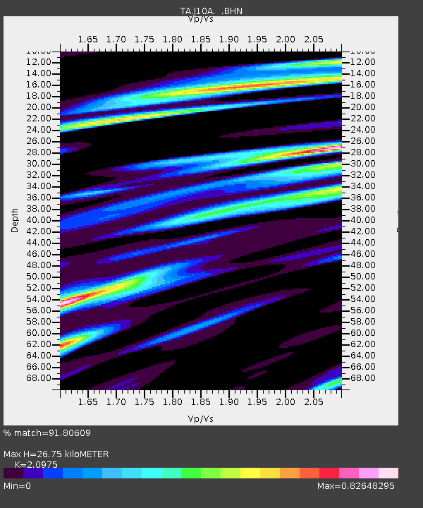
| Estimated Moho Depth: |
26.75 km |
| Estimated Crust Vp/Vs: |
2.10 |
| Assumed Crust Vp: |
6.291 km/s |
| Estimated Crust Vs: |
2.999 km/s |
| Estimated Crust Poisson's Ratio: |
0.35 |
|
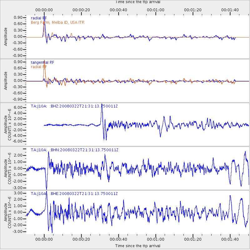
| Radial Match: |
91.80609 % |
| Radial Bump: |
339 |
| Transverse Match: |
63.75601 % |
| Transverse Bump: |
400 |
| SOD ConfigId: |
2564 |
| Insert Time: |
2010-03-07 04:26:24.435 +0000 |
| GWidth: |
2.5 |
| Max Bumps: |
400 |
| Tol: |
0.001 |
|
Signal To Noise
| Channel | StoN | STA | LTA |
| TA:J10A: :BHN:20080322T21:31:13.750011Z | 5.814314 | 1.332804E-6 | 2.2922808E-7 |
| TA:J10A: :BHE:20080322T21:31:13.750011Z | 6.5352364 | 1.6716045E-6 | 2.5578333E-7 |
| TA:J10A: :BHZ:20080322T21:31:13.750011Z | 24.649796 | 3.0591034E-6 | 1.2410258E-7 |
| Arrivals |
| Ps | 4.9 SECOND |
| PpPs | 12 SECOND |
| PsPs/PpSs | 17 SECOND |


