You are here: Home > Network List > TA - USArray Transportable Network (new EarthScope stations) Stations List
> Station J10A Berg Farm, Melba ID, USA > Earthquake Result Viewer
J10A Berg Farm, Melba ID, USA - Earthquake Result Viewer
| Earthquake location: |
Andreanof Islands, Aleutian Is. |
| Earthquake latitude/longitude: |
51.2/-179.0 |
| Earthquake time(UTC): |
2007/12/21 (355) 07:23:35 GMT |
| Earthquake Depth: |
30 km |
| Earthquake Magnitude: |
5.7 MB, 5.5 ML |
| Earthquake Catalog/Contributor: |
WHDF/NEIC |
|
| Network: |
TA USArray Transportable Network (new EarthScope stations) |
| Station: |
J10A Berg Farm, Melba ID, USA |
| Lat/Lon: |
43.43 N/116.77 W |
| Elevation: |
748 m |
|
| Distance: |
41.8 deg |
| Az: |
75.506 deg |
| Baz: |
303.353 deg |
| Ray Param: |
0.073534764 |
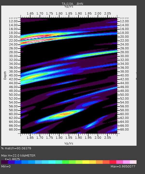
| Estimated Moho Depth: |
22.0 km |
| Estimated Crust Vp/Vs: |
1.68 |
| Assumed Crust Vp: |
6.291 km/s |
| Estimated Crust Vs: |
3.739 km/s |
| Estimated Crust Poisson's Ratio: |
0.23 |
|
| Radial Match: |
80.06379 % |
| Radial Bump: |
400 |
| Transverse Match: |
54.807602 % |
| Transverse Bump: |
400 |
| SOD ConfigId: |
2564 |
| Insert Time: |
2010-03-07 04:26:30.886 +0000 |
| GWidth: |
2.5 |
| Max Bumps: |
400 |
| Tol: |
0.001 |
|
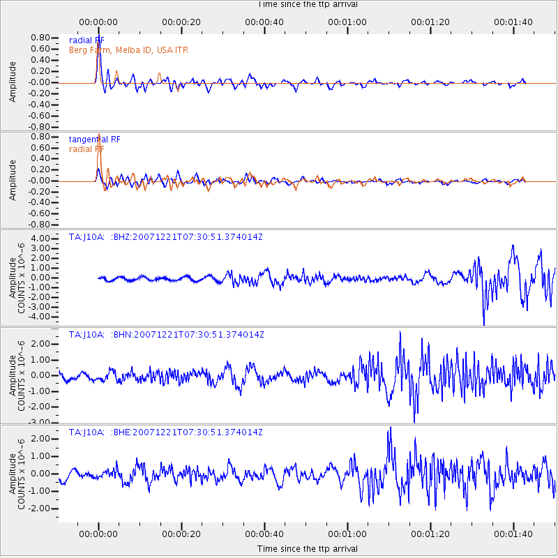
Signal To Noise
| Channel | StoN | STA | LTA |
| TA:J10A: :BHN:20071221T07:30:51.374014Z | 1.6249701 | 2.8396934E-7 | 1.7475358E-7 |
| TA:J10A: :BHE:20071221T07:30:51.374014Z | 0.7331623 | 2.3478435E-7 | 3.202352E-7 |
| TA:J10A: :BHZ:20071221T07:30:51.374014Z | 2.5559342 | 4.4454123E-7 | 1.7392516E-7 |
| Arrivals |
| Ps | 2.6 SECOND |
| PpPs | 8.8 SECOND |
| PsPs/PpSs | 11 SECOND |


