You are here: Home > Network List > TA - USArray Transportable Network (new EarthScope stations) Stations List
> Station J10A Berg Farm, Melba ID, USA > Earthquake Result Viewer
J10A Berg Farm, Melba ID, USA - Earthquake Result Viewer
| Earthquake location: |
South Of Fiji Islands |
| Earthquake latitude/longitude: |
-25.8/179.5 |
| Earthquake time(UTC): |
2007/10/16 (289) 21:05:43 GMT |
| Earthquake Depth: |
509 km |
| Earthquake Magnitude: |
6.2 MB, 6.6 MW, 6.5 MW |
| Earthquake Catalog/Contributor: |
WHDF/NEIC |
|
| Network: |
TA USArray Transportable Network (new EarthScope stations) |
| Station: |
J10A Berg Farm, Melba ID, USA |
| Lat/Lon: |
43.43 N/116.77 W |
| Elevation: |
748 m |
|
| Distance: |
90.3 deg |
| Az: |
40.78 deg |
| Baz: |
233.935 deg |
| Ray Param: |
0.041498374 |
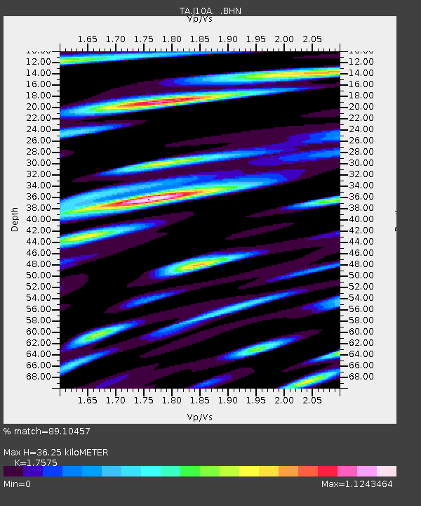
| Estimated Moho Depth: |
36.25 km |
| Estimated Crust Vp/Vs: |
1.76 |
| Assumed Crust Vp: |
6.291 km/s |
| Estimated Crust Vs: |
3.58 km/s |
| Estimated Crust Poisson's Ratio: |
0.26 |
|
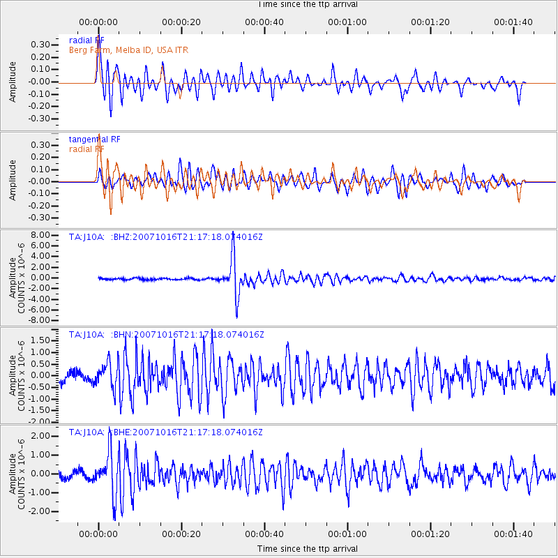
| Radial Match: |
89.10457 % |
| Radial Bump: |
397 |
| Transverse Match: |
80.74128 % |
| Transverse Bump: |
370 |
| SOD ConfigId: |
2564 |
| Insert Time: |
2010-03-07 04:26:39.867 +0000 |
| GWidth: |
2.5 |
| Max Bumps: |
400 |
| Tol: |
0.001 |
|
Signal To Noise
| Channel | StoN | STA | LTA |
| TA:J10A: :BHN:20071016T21:17:18.074016Z | 2.1041832 | 5.5662804E-7 | 2.6453404E-7 |
| TA:J10A: :BHE:20071016T21:17:18.074016Z | 7.060736 | 1.1659534E-6 | 1.65132E-7 |
| TA:J10A: :BHZ:20071016T21:17:18.074016Z | 23.215887 | 3.5748637E-6 | 1.539835E-7 |
| Arrivals |
| Ps | 4.5 SECOND |
| PpPs | 16 SECOND |
| PsPs/PpSs | 20 SECOND |


