You are here: Home > Network List > TA - USArray Transportable Network (new EarthScope stations) Stations List
> Station J10A Berg Farm, Melba ID, USA > Earthquake Result Viewer
J10A Berg Farm, Melba ID, USA - Earthquake Result Viewer
| Earthquake location: |
Taiwan Region |
| Earthquake latitude/longitude: |
24.3/122.2 |
| Earthquake time(UTC): |
2007/09/06 (249) 17:51:26 GMT |
| Earthquake Depth: |
53 km |
| Earthquake Magnitude: |
6.1 MB, 6.2 MW, 6.1 ME |
| Earthquake Catalog/Contributor: |
WHDF/NEIC |
|
| Network: |
TA USArray Transportable Network (new EarthScope stations) |
| Station: |
J10A Berg Farm, Melba ID, USA |
| Lat/Lon: |
43.43 N/116.77 W |
| Elevation: |
748 m |
|
| Distance: |
93.5 deg |
| Az: |
38.725 deg |
| Baz: |
308.442 deg |
| Ray Param: |
0.041218296 |
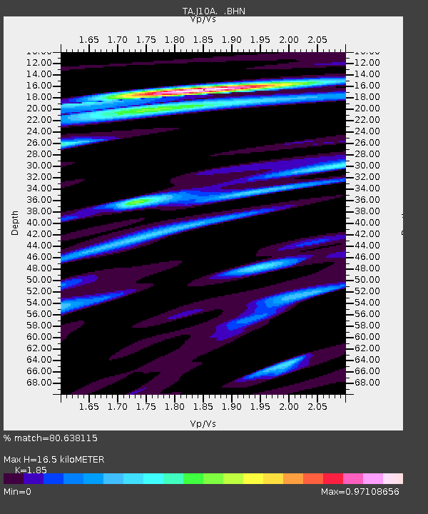
| Estimated Moho Depth: |
16.5 km |
| Estimated Crust Vp/Vs: |
1.85 |
| Assumed Crust Vp: |
6.291 km/s |
| Estimated Crust Vs: |
3.401 km/s |
| Estimated Crust Poisson's Ratio: |
0.29 |
|
| Radial Match: |
80.638115 % |
| Radial Bump: |
400 |
| Transverse Match: |
75.09623 % |
| Transverse Bump: |
400 |
| SOD ConfigId: |
2564 |
| Insert Time: |
2010-03-07 04:26:46.048 +0000 |
| GWidth: |
2.5 |
| Max Bumps: |
400 |
| Tol: |
0.001 |
|
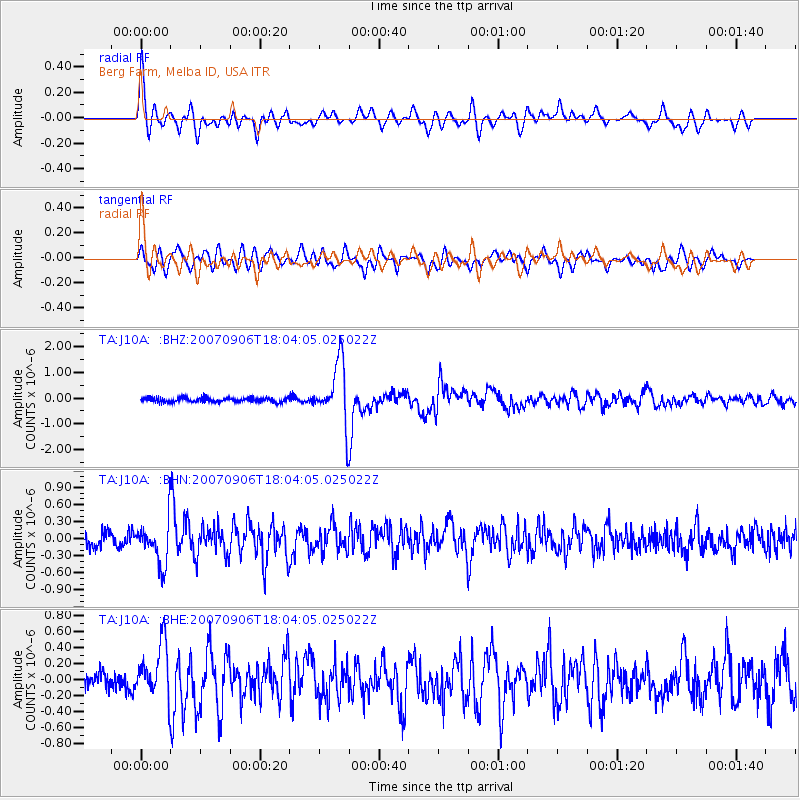
Signal To Noise
| Channel | StoN | STA | LTA |
| TA:J10A: :BHN:20070906T18:04:05.025022Z | 3.4191244 | 3.8106327E-7 | 1.1145055E-7 |
| TA:J10A: :BHE:20070906T18:04:05.025022Z | 2.032953 | 3.394609E-7 | 1.6697922E-7 |
| TA:J10A: :BHZ:20070906T18:04:05.025022Z | 13.928953 | 1.1880511E-6 | 8.529364E-8 |
| Arrivals |
| Ps | 2.3 SECOND |
| PpPs | 7.3 SECOND |
| PsPs/PpSs | 9.6 SECOND |


