You are here: Home > Network List > TA - USArray Transportable Network (new EarthScope stations) Stations List
> Station J10A Berg Farm, Melba ID, USA > Earthquake Result Viewer
J10A Berg Farm, Melba ID, USA - Earthquake Result Viewer
| Earthquake location: |
Galapagos Islands, Ecuador |
| Earthquake latitude/longitude: |
-0.6/-91.3 |
| Earthquake time(UTC): |
2007/08/29 (241) 22:10:10 GMT |
| Earthquake Depth: |
23 km |
| Earthquake Magnitude: |
5.6 MB, 4.8 MS, 5.4 MW |
| Earthquake Catalog/Contributor: |
WHDF/NEIC |
|
| Network: |
TA USArray Transportable Network (new EarthScope stations) |
| Station: |
J10A Berg Farm, Melba ID, USA |
| Lat/Lon: |
43.43 N/116.77 W |
| Elevation: |
748 m |
|
| Distance: |
49.4 deg |
| Az: |
335.654 deg |
| Baz: |
145.541 deg |
| Ray Param: |
0.06871698 |
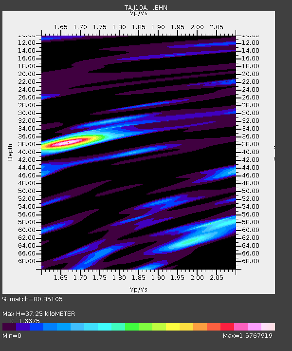
| Estimated Moho Depth: |
37.25 km |
| Estimated Crust Vp/Vs: |
1.67 |
| Assumed Crust Vp: |
6.291 km/s |
| Estimated Crust Vs: |
3.773 km/s |
| Estimated Crust Poisson's Ratio: |
0.22 |
|
| Radial Match: |
80.85105 % |
| Radial Bump: |
400 |
| Transverse Match: |
74.78982 % |
| Transverse Bump: |
400 |
| SOD ConfigId: |
2564 |
| Insert Time: |
2010-03-07 04:26:51.188 +0000 |
| GWidth: |
2.5 |
| Max Bumps: |
400 |
| Tol: |
0.001 |
|

Signal To Noise
| Channel | StoN | STA | LTA |
| TA:J10A: :BHN:20070829T22:18:27.150001Z | 1.2973119 | 1.4840599E-7 | 1.14395E-7 |
| TA:J10A: :BHE:20070829T22:18:27.150001Z | 1.2120088 | 1.2414196E-7 | 1.02426625E-7 |
| TA:J10A: :BHZ:20070829T22:18:27.150001Z | 2.0934796 | 2.761977E-7 | 1.3193237E-7 |
| Arrivals |
| Ps | 4.2 SECOND |
| PpPs | 15 SECOND |
| PsPs/PpSs | 19 SECOND |


