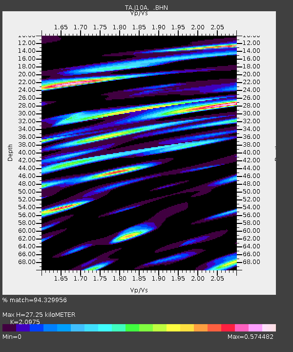
J10A Berg Farm, Melba ID, USA - Earthquake Result Viewer

Earthquake location: Andreanof Islands, Aleutian Is.
Earthquake latitude/longitude: 51.8/-176.3
Earthquake time(UTC): 2007/07/13 (194) 21:54:43 GMT
Earthquake Depth: 35 km
Earthquake Magnitude: 5.7 MB, 5.6 MS, 6.0 MW, 5.9 MW
Earthquake Catalog/Contributor: WHDF/NEIC
Network: TA USArray Transportable Network (new EarthScope stations)
Station: J10A Berg Farm, Melba ID, USA
Lat/Lon: 43.43 N/116.77 W
Elevation: 748 m
Distance: 40.0 deg
Az: 77.853 deg
Baz: 303.637 deg
Ray Param: 0.074603856
Estimated Moho Depth: 27.25 km
Estimated Crust Vp/Vs: 2.10
Assumed Crust Vp: 6.291 km/s
Estimated Crust Vs: 2.999 km/s
Estimated Crust Poisson's Ratio: 0.35
Radial Match: 94.329956 %
Radial Bump: 400
Transverse Match: 86.0804 %
Transverse Bump: 400
SOD ConfigId: 2564
Insert Time: 2010-03-07 04:27:18.057 +0000
GWidth: 2.5
Max Bumps: 400
Tol: 0.001

Signal To Noise

ChannelStoNSTALTA
TA:J10A: :BHN:20070713T22:01:43.698013Z4.2572734.0479622E-79.508346E-8
TA:J10A: :BHE:20070713T22:01:43.698013Z5.6716454.9201736E-78.675038E-8
TA:J10A: :BHZ:20070713T22:01:43.698013Z11.3822889.794891E-78.6053795E-8
Arrivals
Ps5.0 SECOND
PpPs13 SECOND
PsPs/PpSs18 SECOND