You are here: Home > Network List > TA - USArray Transportable Network (new EarthScope stations) Stations List
> Station J10A Berg Farm, Melba ID, USA > Earthquake Result Viewer
J10A Berg Farm, Melba ID, USA - Earthquake Result Viewer
| Earthquake location: |
Solomon Islands |
| Earthquake latitude/longitude: |
-8.5/157.0 |
| Earthquake time(UTC): |
2007/04/01 (091) 20:39:56 GMT |
| Earthquake Depth: |
10 km |
| Earthquake Magnitude: |
6.8 MB, 7.9 MS, 8.1 MW, 7.7 ME |
| Earthquake Catalog/Contributor: |
WHDF/NEIC |
|
| Network: |
TA USArray Transportable Network (new EarthScope stations) |
| Station: |
J10A Berg Farm, Melba ID, USA |
| Lat/Lon: |
43.43 N/116.77 W |
| Elevation: |
748 m |
|
| Distance: |
93.0 deg |
| Az: |
46.713 deg |
| Baz: |
261.273 deg |
| Ray Param: |
0.041348737 |
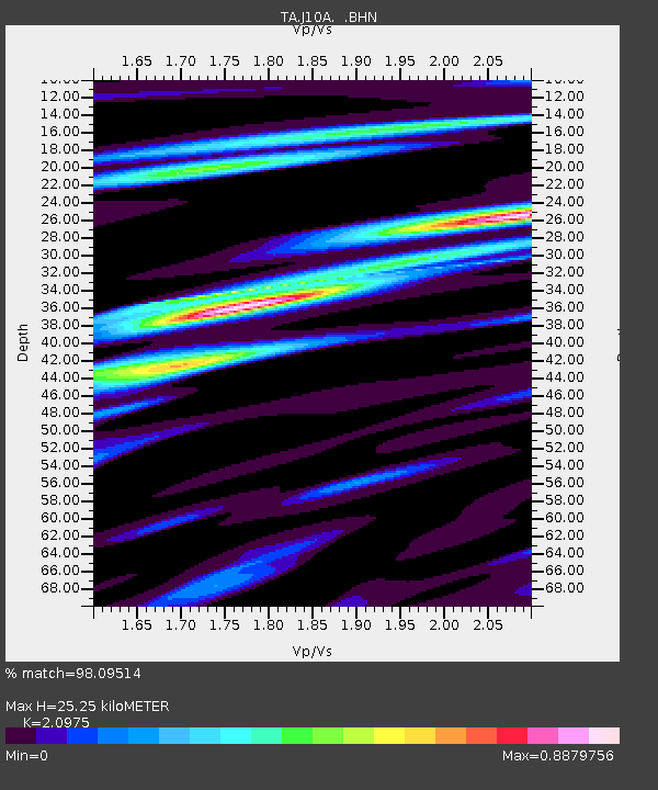
| Estimated Moho Depth: |
25.25 km |
| Estimated Crust Vp/Vs: |
2.10 |
| Assumed Crust Vp: |
6.291 km/s |
| Estimated Crust Vs: |
2.999 km/s |
| Estimated Crust Poisson's Ratio: |
0.35 |
|
| Radial Match: |
98.09514 % |
| Radial Bump: |
400 |
| Transverse Match: |
92.02091 % |
| Transverse Bump: |
400 |
| SOD ConfigId: |
2564 |
| Insert Time: |
2010-03-07 04:27:23.023 +0000 |
| GWidth: |
2.5 |
| Max Bumps: |
400 |
| Tol: |
0.001 |
|
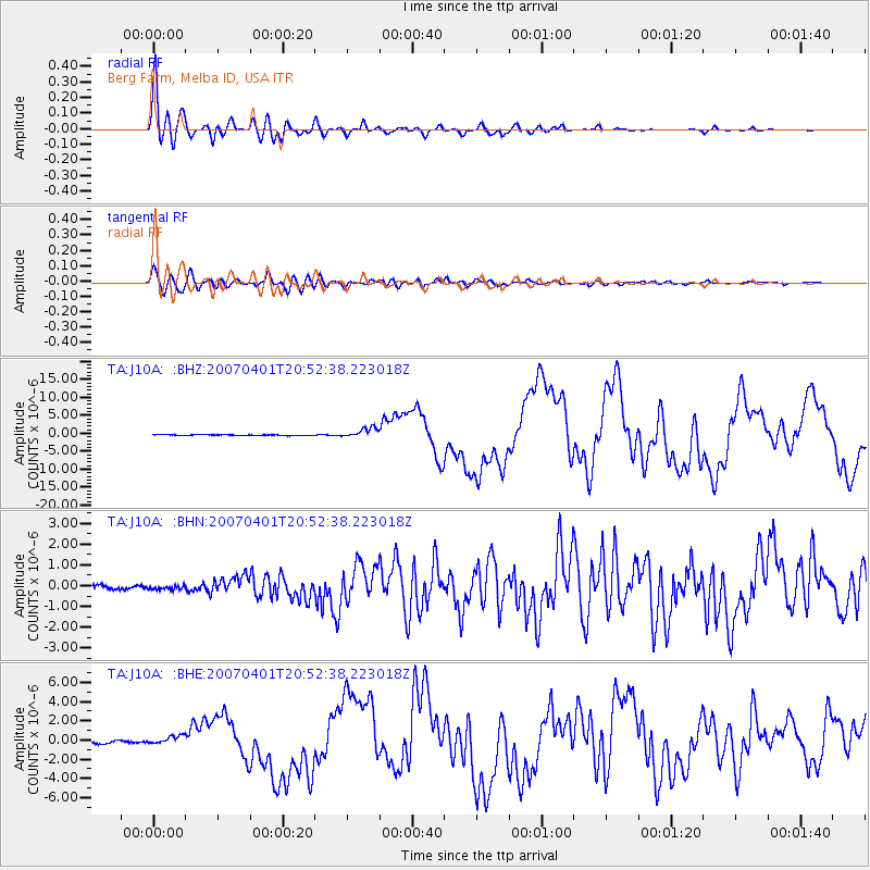
Signal To Noise
| Channel | StoN | STA | LTA |
| TA:J10A: :BHN:20070401T20:52:38.223018Z | 1.0321342 | 9.293578E-8 | 9.004235E-8 |
| TA:J10A: :BHE:20070401T20:52:38.223018Z | 3.8858886 | 4.3842647E-7 | 1.1282528E-7 |
| TA:J10A: :BHZ:20070401T20:52:38.223018Z | 12.668729 | 1.3678584E-6 | 1.0797124E-7 |
| Arrivals |
| Ps | 4.5 SECOND |
| PpPs | 12 SECOND |
| PsPs/PpSs | 17 SECOND |


