You are here: Home > Network List > TA - USArray Transportable Network (new EarthScope stations) Stations List
> Station J10A Berg Farm, Melba ID, USA > Earthquake Result Viewer
J10A Berg Farm, Melba ID, USA - Earthquake Result Viewer
| Earthquake location: |
East Of Kuril Islands |
| Earthquake latitude/longitude: |
46.2/154.5 |
| Earthquake time(UTC): |
2007/01/13 (013) 04:23:21 GMT |
| Earthquake Depth: |
10 km |
| Earthquake Magnitude: |
7.3 MB, 8.2 MS, 8.1 MW, 7.9 MW |
| Earthquake Catalog/Contributor: |
WHDF/NEIC |
|
| Network: |
TA USArray Transportable Network (new EarthScope stations) |
| Station: |
J10A Berg Farm, Melba ID, USA |
| Lat/Lon: |
43.43 N/116.77 W |
| Elevation: |
748 m |
|
| Distance: |
59.7 deg |
| Az: |
57.524 deg |
| Baz: |
306.521 deg |
| Ray Param: |
0.062017225 |
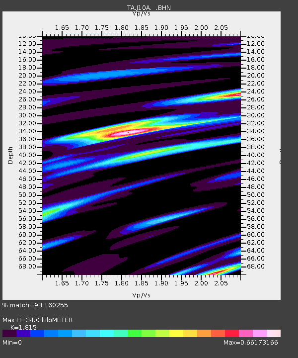
| Estimated Moho Depth: |
34.0 km |
| Estimated Crust Vp/Vs: |
1.82 |
| Assumed Crust Vp: |
6.291 km/s |
| Estimated Crust Vs: |
3.466 km/s |
| Estimated Crust Poisson's Ratio: |
0.28 |
|
| Radial Match: |
98.160255 % |
| Radial Bump: |
400 |
| Transverse Match: |
86.57626 % |
| Transverse Bump: |
400 |
| SOD ConfigId: |
2564 |
| Insert Time: |
2010-03-07 04:27:30.538 +0000 |
| GWidth: |
2.5 |
| Max Bumps: |
400 |
| Tol: |
0.001 |
|
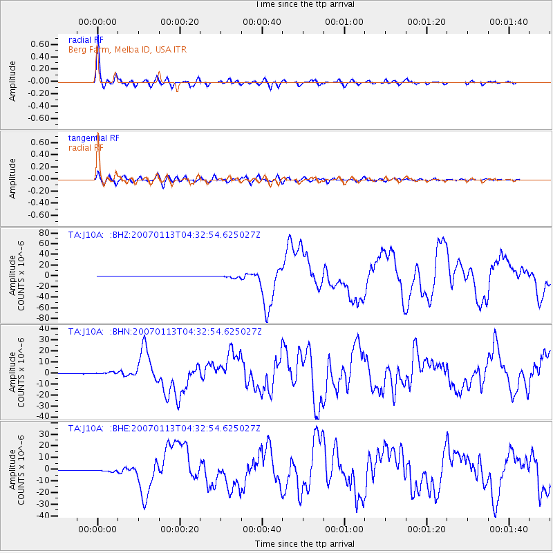
Signal To Noise
| Channel | StoN | STA | LTA |
| TA:J10A: :BHN:20070113T04:32:54.625027Z | 5.350331 | 9.229669E-7 | 1.725065E-7 |
| TA:J10A: :BHE:20070113T04:32:54.625027Z | 4.435434 | 9.8855E-7 | 2.228756E-7 |
| TA:J10A: :BHZ:20070113T04:32:54.625027Z | 12.520815 | 2.48622E-6 | 1.9856695E-7 |
| Arrivals |
| Ps | 4.6 SECOND |
| PpPs | 15 SECOND |
| PsPs/PpSs | 19 SECOND |


