You are here: Home > Network List > TA - USArray Transportable Network (new EarthScope stations) Stations List
> Station J10A Berg Farm, Melba ID, USA > Earthquake Result Viewer
J10A Berg Farm, Melba ID, USA - Earthquake Result Viewer
| Earthquake location: |
Near Coast Of Guatemala |
| Earthquake latitude/longitude: |
13.6/-90.6 |
| Earthquake time(UTC): |
2008/04/15 (106) 03:03:04 GMT |
| Earthquake Depth: |
33 km |
| Earthquake Magnitude: |
5.6 MB, 5.8 MS, 6.1 MW, 6.1 MW |
| Earthquake Catalog/Contributor: |
WHDF/NEIC |
|
| Network: |
TA USArray Transportable Network (new EarthScope stations) |
| Station: |
J10A Berg Farm, Melba ID, USA |
| Lat/Lon: |
43.43 N/116.77 W |
| Elevation: |
748 m |
|
| Distance: |
37.3 deg |
| Az: |
327.979 deg |
| Baz: |
134.947 deg |
| Ray Param: |
0.076151825 |
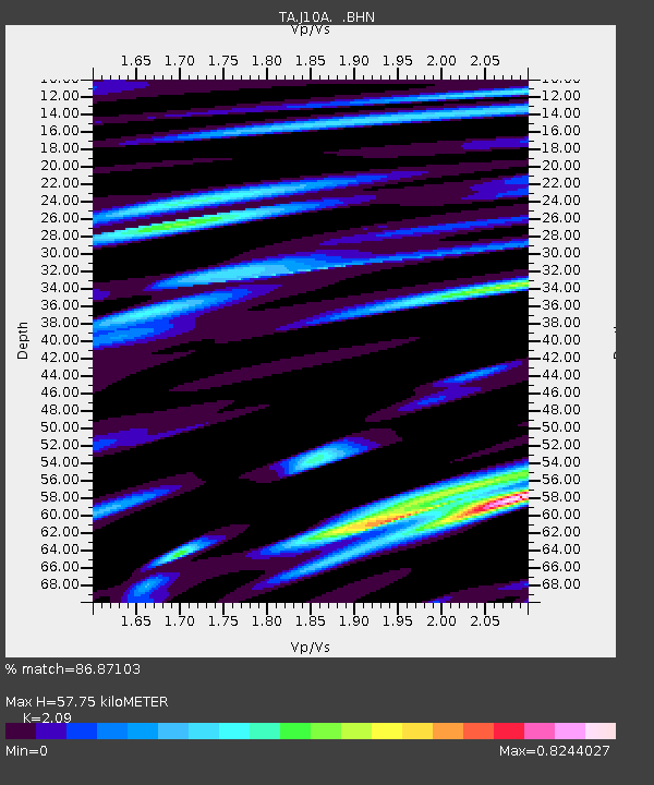
| Estimated Moho Depth: |
57.75 km |
| Estimated Crust Vp/Vs: |
2.09 |
| Assumed Crust Vp: |
6.291 km/s |
| Estimated Crust Vs: |
3.01 km/s |
| Estimated Crust Poisson's Ratio: |
0.35 |
|
| Radial Match: |
86.87103 % |
| Radial Bump: |
400 |
| Transverse Match: |
64.57384 % |
| Transverse Bump: |
400 |
| SOD ConfigId: |
2504 |
| Insert Time: |
2010-03-07 04:27:36.226 +0000 |
| GWidth: |
2.5 |
| Max Bumps: |
400 |
| Tol: |
0.001 |
|

Signal To Noise
| Channel | StoN | STA | LTA |
| TA:J10A: :BHN:20080415T03:09:43.175015Z | 8.410675 | 1.5351658E-6 | 1.8252588E-7 |
| TA:J10A: :BHE:20080415T03:09:43.175015Z | 3.1757407 | 4.795898E-7 | 1.5101668E-7 |
| TA:J10A: :BHZ:20080415T03:09:43.175015Z | 2.7574503 | 6.3489347E-7 | 2.3024656E-7 |
| Arrivals |
| Ps | 11 SECOND |
| PpPs | 27 SECOND |
| PsPs/PpSs | 37 SECOND |


