You are here: Home > Network List > TA - USArray Transportable Network (new EarthScope stations) Stations List
> Station J10A Berg Farm, Melba ID, USA > Earthquake Result Viewer
J10A Berg Farm, Melba ID, USA - Earthquake Result Viewer
| Earthquake location: |
Solomon Islands |
| Earthquake latitude/longitude: |
-10.5/161.3 |
| Earthquake time(UTC): |
2008/06/03 (155) 16:20:50 GMT |
| Earthquake Depth: |
84 km |
| Earthquake Magnitude: |
6.2 MB, 6.2 MW, 6.2 MW |
| Earthquake Catalog/Contributor: |
WHDF/NEIC |
|
| Network: |
TA USArray Transportable Network (new EarthScope stations) |
| Station: |
J10A Berg Farm, Melba ID, USA |
| Lat/Lon: |
43.43 N/116.77 W |
| Elevation: |
748 m |
|
| Distance: |
91.4 deg |
| Az: |
46.186 deg |
| Baz: |
256.92 deg |
| Ray Param: |
0.041586604 |
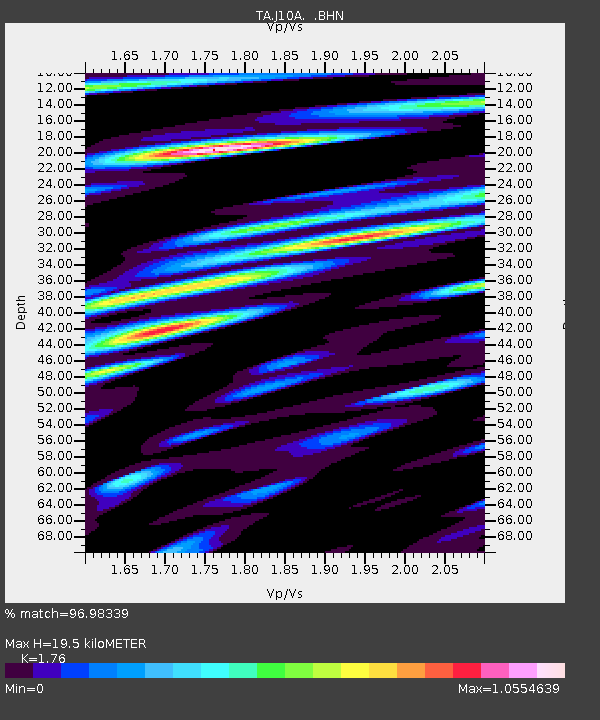
| Estimated Moho Depth: |
19.5 km |
| Estimated Crust Vp/Vs: |
1.76 |
| Assumed Crust Vp: |
6.291 km/s |
| Estimated Crust Vs: |
3.575 km/s |
| Estimated Crust Poisson's Ratio: |
0.26 |
|
| Radial Match: |
96.98339 % |
| Radial Bump: |
400 |
| Transverse Match: |
92.99481 % |
| Transverse Bump: |
400 |
| SOD ConfigId: |
2504 |
| Insert Time: |
2010-03-07 04:27:51.408 +0000 |
| GWidth: |
2.5 |
| Max Bumps: |
400 |
| Tol: |
0.001 |
|

Signal To Noise
| Channel | StoN | STA | LTA |
| TA:J10A: :BHN:20080603T16:33:15.65002Z | 33.82085 | 2.8618824E-6 | 8.4618875E-8 |
| TA:J10A: :BHE:20080603T16:33:15.65002Z | 2.1493793 | 2.639875E-7 | 1.2282034E-7 |
| TA:J10A: :BHZ:20080603T16:33:15.65002Z | 9.234215 | 9.797067E-7 | 1.0609528E-7 |
| Arrivals |
| Ps | 2.4 SECOND |
| PpPs | 8.4 SECOND |
| PsPs/PpSs | 11 SECOND |


