You are here: Home > Network List > IW - Intermountain West Stations List
> Station MOOW Moose Ponds, Wyoming, USA > Earthquake Result Viewer
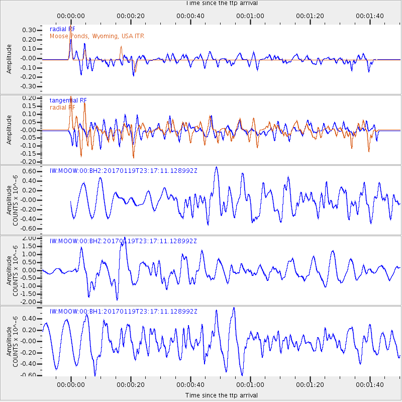
MOOW Moose Ponds, Wyoming, USA - Earthquake Result Viewer
*The percent match for this event was below the threshold and hence no stack was calculated.
| Earthquake location: |
Solomon Islands |
| Earthquake latitude/longitude: |
-10.4/161.3 |
| Earthquake time(UTC): |
2017/01/19 (019) 23:04:20 GMT |
| Earthquake Depth: |
34 km |
| Earthquake Magnitude: |
6.8 mwp |
| Earthquake Catalog/Contributor: |
NEIC PDE/us |
|
| Network: |
IW Intermountain West |
| Station: |
MOOW Moose Ponds, Wyoming, USA |
| Lat/Lon: |
43.75 N/110.74 W |
| Elevation: |
2128 m |
|
| Distance: |
95.6 deg |
| Az: |
46.697 deg |
| Baz: |
261.138 deg |
| Ray Param: |
$rayparam |
*The percent match for this event was below the threshold and hence was not used in the summary stack. |
|
| Radial Match: |
70.370674 % |
| Radial Bump: |
400 |
| Transverse Match: |
44.60353 % |
| Transverse Bump: |
400 |
| SOD ConfigId: |
1943534 |
| Insert Time: |
2017-02-02 23:06:12.071 +0000 |
| GWidth: |
2.5 |
| Max Bumps: |
400 |
| Tol: |
0.001 |
|
Signal To Noise
| Channel | StoN | STA | LTA |
| IW:MOOW:00:BHZ:20170119T23:17:11.128992Z | 2.183203 | 5.8791034E-7 | 2.69288E-7 |
| IW:MOOW:00:BH1:20170119T23:17:11.128992Z | 1.7246096 | 2.7972692E-7 | 1.6219724E-7 |
| IW:MOOW:00:BH2:20170119T23:17:11.128992Z | 0.689513 | 1.4539675E-7 | 2.1086875E-7 |
| Arrivals |
| Ps | |
| PpPs | |
| PsPs/PpSs | |


