You are here: Home > Network List > US - United States National Seismic Network Stations List
> Station HAWA Hanford, Washington, USA > Earthquake Result Viewer
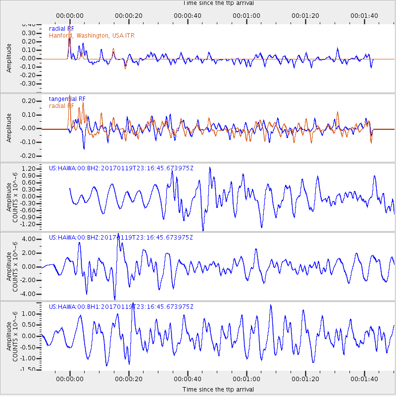
HAWA Hanford, Washington, USA - Earthquake Result Viewer
*The percent match for this event was below the threshold and hence no stack was calculated.
| Earthquake location: |
Solomon Islands |
| Earthquake latitude/longitude: |
-10.4/161.3 |
| Earthquake time(UTC): |
2017/01/19 (019) 23:04:20 GMT |
| Earthquake Depth: |
34 km |
| Earthquake Magnitude: |
6.8 mwp |
| Earthquake Catalog/Contributor: |
NEIC PDE/us |
|
| Network: |
US United States National Seismic Network |
| Station: |
HAWA Hanford, Washington, USA |
| Lat/Lon: |
46.39 N/119.53 W |
| Elevation: |
364 m |
|
| Distance: |
90.1 deg |
| Az: |
42.832 deg |
| Baz: |
255.121 deg |
| Ray Param: |
$rayparam |
*The percent match for this event was below the threshold and hence was not used in the summary stack. |
|
| Radial Match: |
72.090805 % |
| Radial Bump: |
396 |
| Transverse Match: |
52.860188 % |
| Transverse Bump: |
400 |
| SOD ConfigId: |
1943534 |
| Insert Time: |
2017-02-02 23:06:39.460 +0000 |
| GWidth: |
2.5 |
| Max Bumps: |
400 |
| Tol: |
0.001 |
|
Signal To Noise
| Channel | StoN | STA | LTA |
| US:HAWA:00:BHZ:20170119T23:16:45.673975Z | 4.25516 | 1.5386677E-6 | 3.6160043E-7 |
| US:HAWA:00:BH1:20170119T23:16:45.673975Z | 1.1433737 | 5.3158954E-7 | 4.6493068E-7 |
| US:HAWA:00:BH2:20170119T23:16:45.673975Z | 1.9391649 | 5.7967947E-7 | 2.9893255E-7 |
| Arrivals |
| Ps | |
| PpPs | |
| PsPs/PpSs | |


