You are here: Home > Network List > IM - International Miscellaneous Stations Stations List
> Station MK31 Makanchi Array Site 31, Kazakhstan > Earthquake Result Viewer
MK31 Makanchi Array Site 31, Kazakhstan - Earthquake Result Viewer
| Earthquake location: |
Banda Sea |
| Earthquake latitude/longitude: |
-6.5/130.4 |
| Earthquake time(UTC): |
2019/09/21 (264) 19:53:10 GMT |
| Earthquake Depth: |
48 km |
| Earthquake Magnitude: |
5.9 Mww |
| Earthquake Catalog/Contributor: |
NEIC PDE/us |
|
| Network: |
IM International Miscellaneous Stations |
| Station: |
MK31 Makanchi Array Site 31, Kazakhstan |
| Lat/Lon: |
46.79 N/82.29 E |
| Elevation: |
618 m |
|
| Distance: |
68.1 deg |
| Az: |
326.51 deg |
| Baz: |
127.061 deg |
| Ray Param: |
0.056452997 |
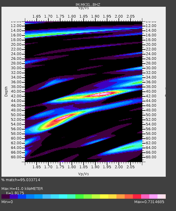
| Estimated Moho Depth: |
41.0 km |
| Estimated Crust Vp/Vs: |
1.92 |
| Assumed Crust Vp: |
6.688 km/s |
| Estimated Crust Vs: |
3.488 km/s |
| Estimated Crust Poisson's Ratio: |
0.31 |
|
| Radial Match: |
95.033714 % |
| Radial Bump: |
400 |
| Transverse Match: |
92.162224 % |
| Transverse Bump: |
400 |
| SOD ConfigId: |
19053131 |
| Insert Time: |
2019-10-05 19:58:52.702 +0000 |
| GWidth: |
2.5 |
| Max Bumps: |
400 |
| Tol: |
0.001 |
|

Signal To Noise
| Channel | StoN | STA | LTA |
| IM:MK31: :BHZ:20190921T20:03:34.673998Z | 25.88011 | 2.868057E-7 | 1.1082089E-8 |
| IM:MK31: :BHN:20190921T20:03:34.673998Z | 24.102541 | 8.029292E-8 | 3.3313052E-9 |
| IM:MK31: :BHE:20190921T20:03:34.673998Z | 30.531258 | 1.5494824E-7 | 5.075069E-9 |
| Arrivals |
| Ps | 5.8 SECOND |
| PpPs | 17 SECOND |
| PsPs/PpSs | 23 SECOND |


