You are here: Home > Network List > TA - USArray Transportable Network (new EarthScope stations) Stations List
> Station G31M Satah River, YT, CAN > Earthquake Result Viewer
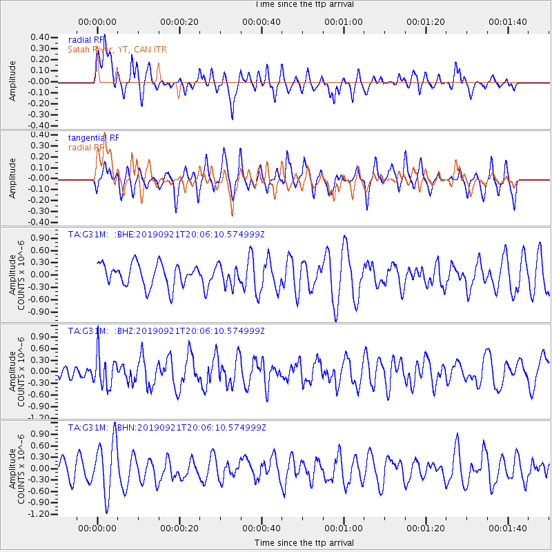
G31M Satah River, YT, CAN - Earthquake Result Viewer
*The percent match for this event was below the threshold and hence no stack was calculated.
| Earthquake location: |
Banda Sea |
| Earthquake latitude/longitude: |
-6.5/130.4 |
| Earthquake time(UTC): |
2019/09/21 (264) 19:53:10 GMT |
| Earthquake Depth: |
48 km |
| Earthquake Magnitude: |
5.9 Mww |
| Earthquake Catalog/Contributor: |
NEIC PDE/us |
|
| Network: |
TA USArray Transportable Network (new EarthScope stations) |
| Station: |
G31M Satah River, YT, CAN |
| Lat/Lon: |
66.92 N/134.27 W |
| Elevation: |
61 m |
|
| Distance: |
98.0 deg |
| Az: |
23.354 deg |
| Baz: |
272.297 deg |
| Ray Param: |
$rayparam |
*The percent match for this event was below the threshold and hence was not used in the summary stack. |
|
| Radial Match: |
49.00121 % |
| Radial Bump: |
380 |
| Transverse Match: |
51.814476 % |
| Transverse Bump: |
370 |
| SOD ConfigId: |
19053131 |
| Insert Time: |
2019-10-05 20:00:19.631 +0000 |
| GWidth: |
2.5 |
| Max Bumps: |
400 |
| Tol: |
0.001 |
|
Signal To Noise
| Channel | StoN | STA | LTA |
| TA:G31M: :BHZ:20190921T20:06:10.574999Z | 2.517445 | 4.2329413E-7 | 1.6814433E-7 |
| TA:G31M: :BHN:20190921T20:06:10.574999Z | 2.3525891 | 7.2628546E-7 | 3.087175E-7 |
| TA:G31M: :BHE:20190921T20:06:10.574999Z | 0.8720849 | 2.3702074E-7 | 2.7178632E-7 |
| Arrivals |
| Ps | |
| PpPs | |
| PsPs/PpSs | |


