You are here: Home > Network List > TA - USArray Transportable Network (new EarthScope stations) Stations List
> Station H31M Peel River, Yukon, CAN > Earthquake Result Viewer
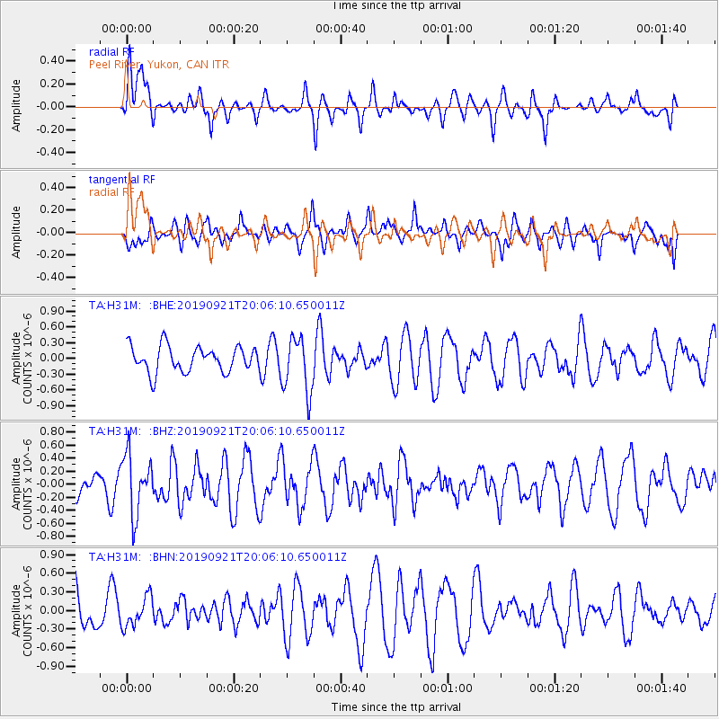
H31M Peel River, Yukon, CAN - Earthquake Result Viewer
*The percent match for this event was below the threshold and hence no stack was calculated.
| Earthquake location: |
Banda Sea |
| Earthquake latitude/longitude: |
-6.5/130.4 |
| Earthquake time(UTC): |
2019/09/21 (264) 19:53:10 GMT |
| Earthquake Depth: |
48 km |
| Earthquake Magnitude: |
5.9 Mww |
| Earthquake Catalog/Contributor: |
NEIC PDE/us |
|
| Network: |
TA USArray Transportable Network (new EarthScope stations) |
| Station: |
H31M Peel River, Yukon, CAN |
| Lat/Lon: |
65.81 N/134.34 W |
| Elevation: |
642 m |
|
| Distance: |
98.0 deg |
| Az: |
24.488 deg |
| Baz: |
272.073 deg |
| Ray Param: |
$rayparam |
*The percent match for this event was below the threshold and hence was not used in the summary stack. |
|
| Radial Match: |
55.520138 % |
| Radial Bump: |
400 |
| Transverse Match: |
49.001904 % |
| Transverse Bump: |
400 |
| SOD ConfigId: |
19053131 |
| Insert Time: |
2019-10-05 20:00:24.356 +0000 |
| GWidth: |
2.5 |
| Max Bumps: |
400 |
| Tol: |
0.001 |
|
Signal To Noise
| Channel | StoN | STA | LTA |
| TA:H31M: :BHZ:20190921T20:06:10.650011Z | 1.7077688 | 4.620649E-7 | 2.7056643E-7 |
| TA:H31M: :BHN:20190921T20:06:10.650011Z | 0.67524755 | 2.4261493E-7 | 3.5929776E-7 |
| TA:H31M: :BHE:20190921T20:06:10.650011Z | 2.2001233 | 5.3394956E-7 | 2.4269073E-7 |
| Arrivals |
| Ps | |
| PpPs | |
| PsPs/PpSs | |


