You are here: Home > Network List > TA - USArray Transportable Network (new EarthScope stations) Stations List
> Station I17K Unalakleet, AK, USA > Earthquake Result Viewer
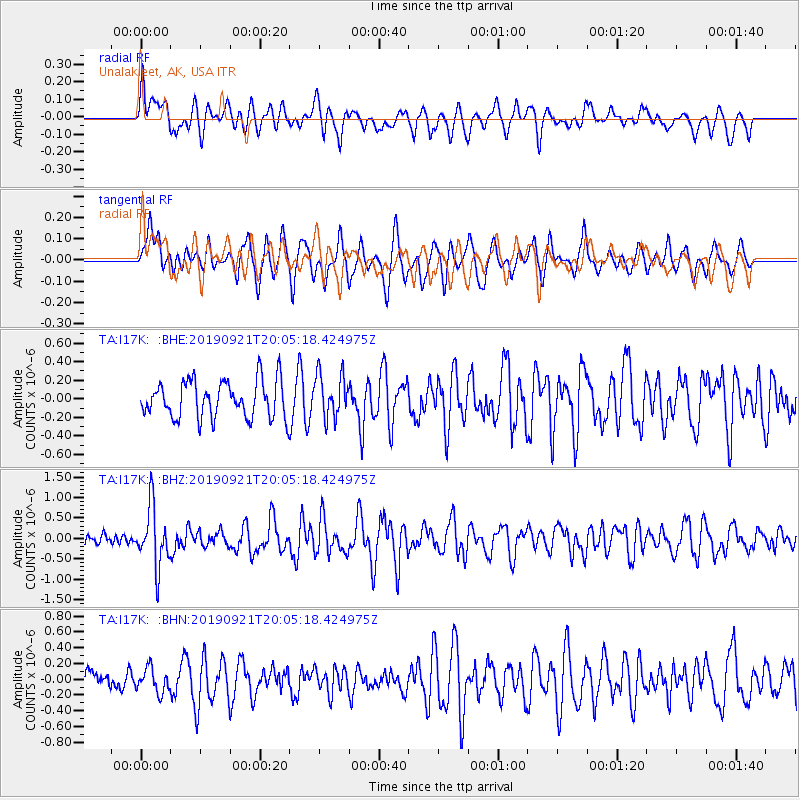
I17K Unalakleet, AK, USA - Earthquake Result Viewer
*The percent match for this event was below the threshold and hence no stack was calculated.
| Earthquake location: |
Banda Sea |
| Earthquake latitude/longitude: |
-6.5/130.4 |
| Earthquake time(UTC): |
2019/09/21 (264) 19:53:10 GMT |
| Earthquake Depth: |
48 km |
| Earthquake Magnitude: |
5.9 Mww |
| Earthquake Catalog/Contributor: |
NEIC PDE/us |
|
| Network: |
TA USArray Transportable Network (new EarthScope stations) |
| Station: |
I17K Unalakleet, AK, USA |
| Lat/Lon: |
63.89 N/160.70 W |
| Elevation: |
105 m |
|
| Distance: |
86.7 deg |
| Az: |
24.421 deg |
| Baz: |
248.172 deg |
| Ray Param: |
$rayparam |
*The percent match for this event was below the threshold and hence was not used in the summary stack. |
|
| Radial Match: |
56.75974 % |
| Radial Bump: |
400 |
| Transverse Match: |
54.652348 % |
| Transverse Bump: |
393 |
| SOD ConfigId: |
19053131 |
| Insert Time: |
2019-10-05 20:00:24.880 +0000 |
| GWidth: |
2.5 |
| Max Bumps: |
400 |
| Tol: |
0.001 |
|
Signal To Noise
| Channel | StoN | STA | LTA |
| TA:I17K: :BHZ:20190921T20:05:18.424975Z | 3.7691479 | 7.29634E-7 | 1.9358062E-7 |
| TA:I17K: :BHN:20190921T20:05:18.424975Z | 0.7544461 | 1.5088389E-7 | 1.9999294E-7 |
| TA:I17K: :BHE:20190921T20:05:18.424975Z | 1.1855363 | 2.3703068E-7 | 1.9993541E-7 |
| Arrivals |
| Ps | |
| PpPs | |
| PsPs/PpSs | |


