You are here: Home > Network List > TA - USArray Transportable Network (new EarthScope stations) Stations List
> Station O17K Koliganek, Bristol Bay, AK, USA > Earthquake Result Viewer
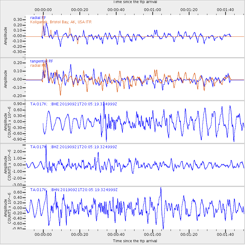
O17K Koliganek, Bristol Bay, AK, USA - Earthquake Result Viewer
*The percent match for this event was below the threshold and hence no stack was calculated.
| Earthquake location: |
Banda Sea |
| Earthquake latitude/longitude: |
-6.5/130.4 |
| Earthquake time(UTC): |
2019/09/21 (264) 19:53:10 GMT |
| Earthquake Depth: |
48 km |
| Earthquake Magnitude: |
5.9 Mww |
| Earthquake Catalog/Contributor: |
NEIC PDE/us |
|
| Network: |
TA USArray Transportable Network (new EarthScope stations) |
| Station: |
O17K Koliganek, Bristol Bay, AK, USA |
| Lat/Lon: |
59.77 N/157.09 W |
| Elevation: |
156 m |
|
| Distance: |
86.9 deg |
| Az: |
28.891 deg |
| Baz: |
251.593 deg |
| Ray Param: |
$rayparam |
*The percent match for this event was below the threshold and hence was not used in the summary stack. |
|
| Radial Match: |
45.332317 % |
| Radial Bump: |
373 |
| Transverse Match: |
52.92681 % |
| Transverse Bump: |
400 |
| SOD ConfigId: |
19053131 |
| Insert Time: |
2019-10-05 20:00:49.454 +0000 |
| GWidth: |
2.5 |
| Max Bumps: |
400 |
| Tol: |
0.001 |
|
Signal To Noise
| Channel | StoN | STA | LTA |
| TA:O17K: :BHZ:20190921T20:05:19.324999Z | 3.3963022 | 8.7215193E-7 | 2.5679455E-7 |
| TA:O17K: :BHN:20190921T20:05:19.324999Z | 2.3454983 | 3.4781965E-7 | 1.4829244E-7 |
| TA:O17K: :BHE:20190921T20:05:19.324999Z | 1.5317507 | 4.457377E-7 | 2.9099886E-7 |
| Arrivals |
| Ps | |
| PpPs | |
| PsPs/PpSs | |


