You are here: Home > Network List > TA - USArray Transportable Network (new EarthScope stations) Stations List
> Station BNLO Ben Lomond (Santa Cruz Mountains), CA, USA > Earthquake Result Viewer
BNLO Ben Lomond (Santa Cruz Mountains), CA, USA - Earthquake Result Viewer
| Earthquake location: |
Chile-Bolivia Border Region |
| Earthquake latitude/longitude: |
-22.3/-67.9 |
| Earthquake time(UTC): |
2005/11/17 (321) 19:26:56 GMT |
| Earthquake Depth: |
163 km |
| Earthquake Magnitude: |
6.0 MB, 6.9 MW, 6.8 MW |
| Earthquake Catalog/Contributor: |
WHDF/NEIC |
|
| Network: |
TA USArray Transportable Network (new EarthScope stations) |
| Station: |
BNLO Ben Lomond (Santa Cruz Mountains), CA, USA |
| Lat/Lon: |
37.13 N/122.17 W |
| Elevation: |
794 m |
|
| Distance: |
78.2 deg |
| Az: |
318.472 deg |
| Baz: |
129.811 deg |
| Ray Param: |
0.049424555 |
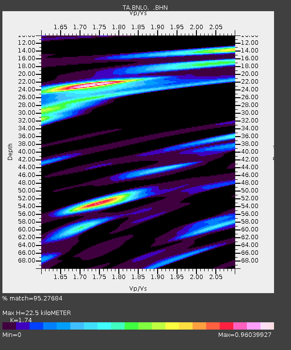
| Estimated Moho Depth: |
22.5 km |
| Estimated Crust Vp/Vs: |
1.74 |
| Assumed Crust Vp: |
6.183 km/s |
| Estimated Crust Vs: |
3.553 km/s |
| Estimated Crust Poisson's Ratio: |
0.25 |
|
| Radial Match: |
95.27684 % |
| Radial Bump: |
398 |
| Transverse Match: |
90.64112 % |
| Transverse Bump: |
400 |
| SOD ConfigId: |
2422 |
| Insert Time: |
2010-03-07 04:30:24.038 +0000 |
| GWidth: |
2.5 |
| Max Bumps: |
400 |
| Tol: |
0.001 |
|
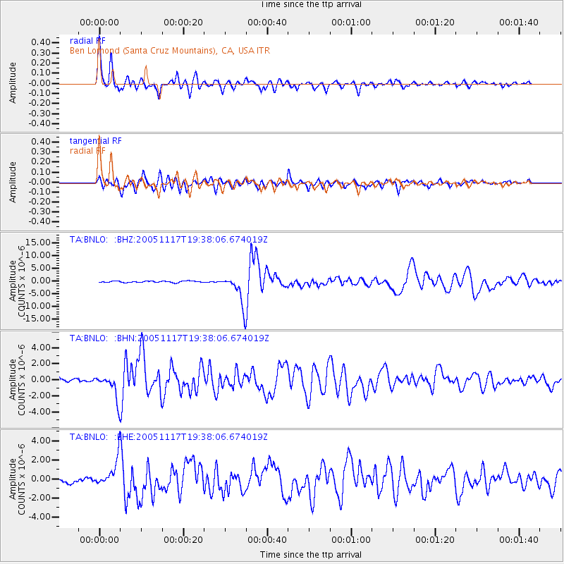
Signal To Noise
| Channel | StoN | STA | LTA |
| TA:BNLO: :BHN:20051117T19:38:06.674019Z | 9.326037 | 1.6298195E-6 | 1.7476013E-7 |
| TA:BNLO: :BHE:20051117T19:38:06.674019Z | 4.522198 | 1.5231088E-6 | 3.368072E-7 |
| TA:BNLO: :BHZ:20051117T19:38:06.674019Z | 21.943226 | 6.256087E-6 | 2.8510334E-7 |
| Arrivals |
| Ps | 2.8 SECOND |
| PpPs | 9.7 SECOND |
| PsPs/PpSs | 12 SECOND |


