You are here: Home > Network List > TA - USArray Transportable Network (new EarthScope stations) Stations List
> Station BNLO Ben Lomond (Santa Cruz Mountains), CA, USA > Earthquake Result Viewer
BNLO Ben Lomond (Santa Cruz Mountains), CA, USA - Earthquake Result Viewer

| Earthquake location: |
South Of Kermadec Islands |
| Earthquake latitude/longitude: |
-32.6/-179.4 |
| Earthquake time(UTC): |
2005/05/16 (136) 03:54:14 GMT |
| Earthquake Depth: |
34 km |
| Earthquake Magnitude: |
6.2 MB, 6.4 MS, 6.6 MW, 6.6 MW |
| Earthquake Catalog/Contributor: |
WHDF/NEIC |
|
| Network: |
TA USArray Transportable Network (new EarthScope stations) |
| Station: |
BNLO Ben Lomond (Santa Cruz Mountains), CA, USA |
| Lat/Lon: |
37.13 N/122.17 W |
| Elevation: |
794 m |
|
| Distance: |
87.5 deg |
| Az: |
42.242 deg |
| Baz: |
225.244 deg |
| Ray Param: |
0.04323294 |
| Estimated Moho Depth: |
25.75 km |
| Estimated Crust Vp/Vs: |
1.61 |
| Assumed Crust Vp: |
6.183 km/s |
| Estimated Crust Vs: |
3.846 km/s |
| Estimated Crust Poisson's Ratio: |
0.18 |
|
| Radial Match: |
87.88345 % |
| Radial Bump: |
379 |
| Transverse Match: |
79.938324 % |
| Transverse Bump: |
400 |
| SOD ConfigId: |
142939 |
| Insert Time: |
2010-03-07 04:30:29.627 +0000 |
| GWidth: |
2.5 |
| Max Bumps: |
400 |
| Tol: |
0.001 |
|
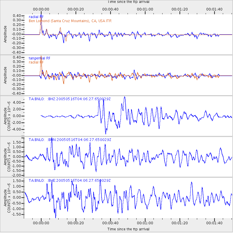
Signal To Noise
| Channel | StoN | STA | LTA |
| TA:BNLO: :BHN:20050516T04:06:27.650029Z | 1.5318414 | 3.4619183E-7 | 2.2599717E-7 |
| TA:BNLO: :BHE:20050516T04:06:27.650029Z | 1.6483252 | 4.2911864E-7 | 2.6033615E-7 |
| TA:BNLO: :BHZ:20050516T04:06:27.650029Z | 7.8195105 | 1.6558181E-6 | 2.1175471E-7 |
| Arrivals |
| Ps | 2.6 SECOND |
| PpPs | 11 SECOND |
| PsPs/PpSs | 13 SECOND |


