You are here: Home > Network List > TA - USArray Transportable Network (new EarthScope stations) Stations List
> Station E20K Nigu River, AK, USA > Earthquake Result Viewer
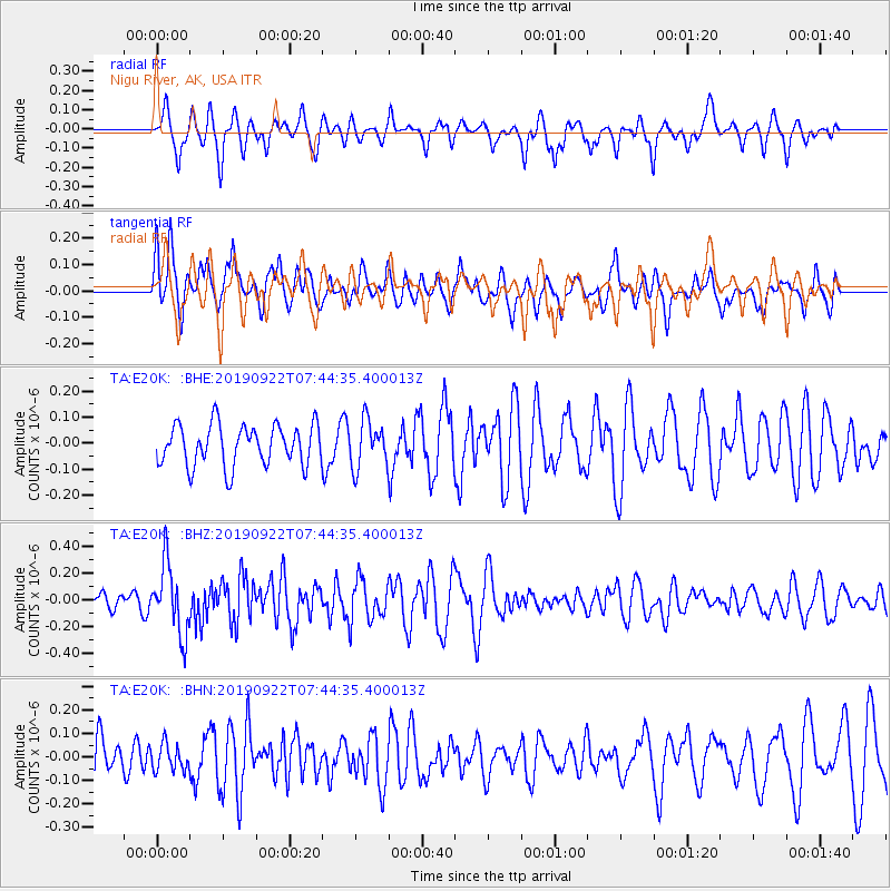
E20K Nigu River, AK, USA - Earthquake Result Viewer
*The percent match for this event was below the threshold and hence no stack was calculated.
| Earthquake location: |
Tonga Islands |
| Earthquake latitude/longitude: |
-15.6/-173.1 |
| Earthquake time(UTC): |
2019/09/22 (265) 07:32:33 GMT |
| Earthquake Depth: |
8.6 km |
| Earthquake Magnitude: |
5.6 Mww |
| Earthquake Catalog/Contributor: |
NEIC PDE/us |
|
| Network: |
TA USArray Transportable Network (new EarthScope stations) |
| Station: |
E20K Nigu River, AK, USA |
| Lat/Lon: |
68.26 N/156.19 W |
| Elevation: |
866 m |
|
| Distance: |
84.5 deg |
| Az: |
6.262 deg |
| Baz: |
196.39 deg |
| Ray Param: |
$rayparam |
*The percent match for this event was below the threshold and hence was not used in the summary stack. |
|
| Radial Match: |
65.761086 % |
| Radial Bump: |
338 |
| Transverse Match: |
57.126766 % |
| Transverse Bump: |
400 |
| SOD ConfigId: |
19053131 |
| Insert Time: |
2019-10-06 07:40:57.851 +0000 |
| GWidth: |
2.5 |
| Max Bumps: |
400 |
| Tol: |
0.001 |
|
Signal To Noise
| Channel | StoN | STA | LTA |
| TA:E20K: :BHZ:20190922T07:44:35.400013Z | 3.1755173 | 2.595005E-7 | 8.171913E-8 |
| TA:E20K: :BHN:20190922T07:44:35.400013Z | 0.62273514 | 5.6103207E-8 | 9.00916E-8 |
| TA:E20K: :BHE:20190922T07:44:35.400013Z | 1.1350957 | 8.930806E-8 | 7.867888E-8 |
| Arrivals |
| Ps | |
| PpPs | |
| PsPs/PpSs | |


