You are here: Home > Network List > TA - USArray Transportable Network (new EarthScope stations) Stations List
> Station BNLO Ben Lomond (Santa Cruz Mountains), CA, USA > Earthquake Result Viewer
BNLO Ben Lomond (Santa Cruz Mountains), CA, USA - Earthquake Result Viewer
| Earthquake location: |
South Of Panama |
| Earthquake latitude/longitude: |
6.8/-82.4 |
| Earthquake time(UTC): |
2005/08/27 (239) 18:38:20 GMT |
| Earthquake Depth: |
10 km |
| Earthquake Magnitude: |
5.6 MB, 5.6 MS, 6.2 MW, 6.1 MW |
| Earthquake Catalog/Contributor: |
WHDF/NEIC |
|
| Network: |
TA USArray Transportable Network (new EarthScope stations) |
| Station: |
BNLO Ben Lomond (Santa Cruz Mountains), CA, USA |
| Lat/Lon: |
37.13 N/122.17 W |
| Elevation: |
794 m |
|
| Distance: |
47.1 deg |
| Az: |
315.745 deg |
| Baz: |
119.877 deg |
| Ray Param: |
0.0702362 |
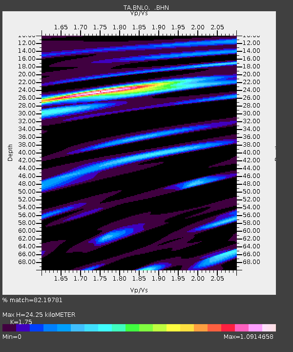
| Estimated Moho Depth: |
24.25 km |
| Estimated Crust Vp/Vs: |
1.75 |
| Assumed Crust Vp: |
6.183 km/s |
| Estimated Crust Vs: |
3.533 km/s |
| Estimated Crust Poisson's Ratio: |
0.26 |
|
| Radial Match: |
82.19781 % |
| Radial Bump: |
355 |
| Transverse Match: |
66.083176 % |
| Transverse Bump: |
400 |
| SOD ConfigId: |
2475 |
| Insert Time: |
2010-03-07 04:30:35.362 +0000 |
| GWidth: |
2.5 |
| Max Bumps: |
400 |
| Tol: |
0.001 |
|
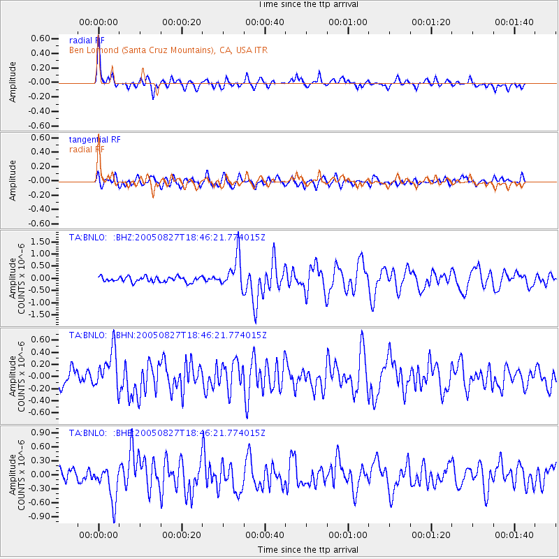
Signal To Noise
| Channel | StoN | STA | LTA |
| TA:BNLO: :BHN:20050827T18:46:21.774015Z | 2.244495 | 3.2213225E-7 | 1.4352105E-7 |
| TA:BNLO: :BHE:20050827T18:46:21.774015Z | 2.8548894 | 3.8206E-7 | 1.3382655E-7 |
| TA:BNLO: :BHZ:20050827T18:46:21.774015Z | 6.291255 | 6.8514316E-7 | 1.0890405E-7 |
| Arrivals |
| Ps | 3.1 SECOND |
| PpPs | 10 SECOND |
| PsPs/PpSs | 13 SECOND |


