You are here: Home > Network List > TA - USArray Transportable Network (new EarthScope stations) Stations List
> Station BNLO Ben Lomond (Santa Cruz Mountains), CA, USA > Earthquake Result Viewer
BNLO Ben Lomond (Santa Cruz Mountains), CA, USA - Earthquake Result Viewer
| Earthquake location: |
Northern Peru |
| Earthquake latitude/longitude: |
-5.7/-76.4 |
| Earthquake time(UTC): |
2005/09/26 (269) 01:55:37 GMT |
| Earthquake Depth: |
115 km |
| Earthquake Magnitude: |
6.7 MB, 7.5 MW, 7.5 MW |
| Earthquake Catalog/Contributor: |
WHDF/NEIC |
|
| Network: |
TA USArray Transportable Network (new EarthScope stations) |
| Station: |
BNLO Ben Lomond (Santa Cruz Mountains), CA, USA |
| Lat/Lon: |
37.13 N/122.17 W |
| Elevation: |
794 m |
|
| Distance: |
60.3 deg |
| Az: |
318.745 deg |
| Baz: |
124.806 deg |
| Ray Param: |
0.06129321 |
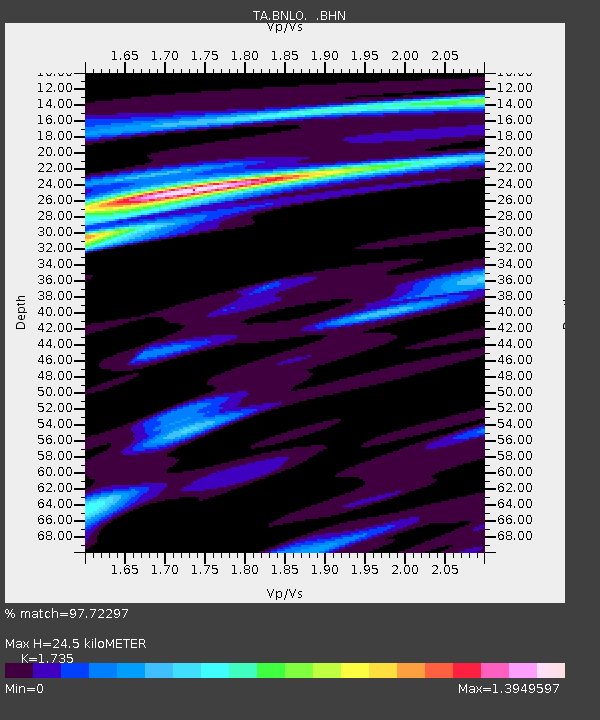
| Estimated Moho Depth: |
24.5 km |
| Estimated Crust Vp/Vs: |
1.74 |
| Assumed Crust Vp: |
6.183 km/s |
| Estimated Crust Vs: |
3.563 km/s |
| Estimated Crust Poisson's Ratio: |
0.25 |
|
| Radial Match: |
97.72297 % |
| Radial Bump: |
395 |
| Transverse Match: |
91.08319 % |
| Transverse Bump: |
400 |
| SOD ConfigId: |
2475 |
| Insert Time: |
2010-03-07 04:30:38.046 +0000 |
| GWidth: |
2.5 |
| Max Bumps: |
400 |
| Tol: |
0.001 |
|
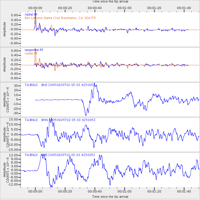
Signal To Noise
| Channel | StoN | STA | LTA |
| TA:BNLO: :BHN:20050926T02:05:03.425005Z | 14.713355 | 5.39387E-6 | 3.6659688E-7 |
| TA:BNLO: :BHE:20050926T02:05:03.425005Z | 25.967394 | 6.6932953E-6 | 2.5775768E-7 |
| TA:BNLO: :BHZ:20050926T02:05:03.425005Z | 42.75862 | 1.7030354E-5 | 3.9829052E-7 |
| Arrivals |
| Ps | 3.0 SECOND |
| PpPs | 10 SECOND |
| PsPs/PpSs | 13 SECOND |


