You are here: Home > Network List > TA - USArray Transportable Network (new EarthScope stations) Stations List
> Station BNLO Ben Lomond (Santa Cruz Mountains), CA, USA > Earthquake Result Viewer
BNLO Ben Lomond (Santa Cruz Mountains), CA, USA - Earthquake Result Viewer
| Earthquake location: |
Sea Of Japan |
| Earthquake latitude/longitude: |
36.8/134.9 |
| Earthquake time(UTC): |
2007/07/16 (197) 14:17:37 GMT |
| Earthquake Depth: |
350 km |
| Earthquake Magnitude: |
6.2 MB, 6.8 MW, 6.8 MW |
| Earthquake Catalog/Contributor: |
WHDF/NEIC |
|
| Network: |
TA USArray Transportable Network (new EarthScope stations) |
| Station: |
BNLO Ben Lomond (Santa Cruz Mountains), CA, USA |
| Lat/Lon: |
37.13 N/122.17 W |
| Elevation: |
794 m |
|
| Distance: |
77.6 deg |
| Az: |
52.878 deg |
| Baz: |
306.801 deg |
| Ray Param: |
0.049227268 |
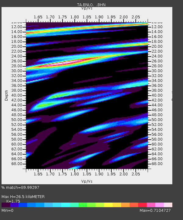
| Estimated Moho Depth: |
26.5 km |
| Estimated Crust Vp/Vs: |
1.75 |
| Assumed Crust Vp: |
6.183 km/s |
| Estimated Crust Vs: |
3.533 km/s |
| Estimated Crust Poisson's Ratio: |
0.26 |
|
| Radial Match: |
89.99297 % |
| Radial Bump: |
400 |
| Transverse Match: |
62.42083 % |
| Transverse Bump: |
400 |
| SOD ConfigId: |
2564 |
| Insert Time: |
2010-03-07 04:30:43.767 +0000 |
| GWidth: |
2.5 |
| Max Bumps: |
400 |
| Tol: |
0.001 |
|
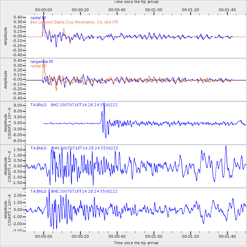
Signal To Noise
| Channel | StoN | STA | LTA |
| TA:BNLO: :BHN:20070716T14:28:24.550022Z | 3.9378679 | 7.278376E-7 | 1.8483037E-7 |
| TA:BNLO: :BHE:20070716T14:28:24.550022Z | 5.5066113 | 1.145436E-6 | 2.0801106E-7 |
| TA:BNLO: :BHZ:20070716T14:28:24.550022Z | 23.657124 | 3.8559397E-6 | 1.6299276E-7 |
| Arrivals |
| Ps | 3.3 SECOND |
| PpPs | 11 SECOND |
| PsPs/PpSs | 15 SECOND |


